12 Upper Air Circulation: Jet Streams, Origin, Types and Distribution
Dr. Jitender Saroha

Contents
Introduction
Learning Objectives
Upper Air Westerlies
Rossby Waves and Index Cycle of Jet Stream
First Stage
Second Stage
Third Stage
Fourth Stage
Jet Streams: Definition and Characteristics
Origin of Jet Streams
Types and Distribution of Jet Streams
Polar Jet Stream
Subtropical Jet Stream
Subtropical Easterly Jet Stream
Stratospheric Subpolar Jet Streams
Local and Regional Jet Streams
Significance of Jet Streams
Summary and conclusions
Multiple Choice Questions
Answers:
References
Web Links
Introduction
One of your common observations is the movement or drift of clouds. This movement, sometimes fast and sometimes slow, indicates that air moves in upper troposphere also. Before World War II, upper air observations on scientific basis were very limited. Volcanic eruptions, balloons, aircrafts and satellite imageries have provided a great deal of data to prove the existence of upper air westerlies, Rossby waves and their high velocity core,i.e. jet streams. Jet streams play a significant role in determining the surface weather conditions, including latitudinal heat transfer, temperate cyclones and monsoon mechanism. In this module our focus is on the understanding of upper air circulation, especially jet streams.
Learning Objectives
After studying this module, you will be able to:
define upper air westerlies, Rossby waves and jet streams; explain the index cycle of jet streams;
explain the origin and characteristics of jet streams; describe the types and distribution of jet streams; and
highlight the significance of jet streams in determining surface weather conditions.
Upper Air Westerlies
Temperature, atmospheric pressure and air circulations are quite different in upper part of troposphere as compared with those prevailing near the earth’s surface. The effects of frictional drag of surface irregularities are absent or prevail in limited areas upto limited height, and are small enough to discard with respect to upper air. The upper air circulars are predominantly
geostrophic. Recall that pressure gradient force (PGF), which is always perpendicular to isobars, onsets motion of parcel of air from high pressure area to low pressure area. You also have idea from previous modules on planetary pressure belts and general atmospheric circulation, that as winds start blowing, due to rotation of earth coriolis force (CF) deflects it towards right in northern hemisphere, and its magnitude is proportional to wind speed. Therefore, as the parcel of air accelerates its deflection increases. Finally, a situation comes when wind turns so much that it starts blowing parallel to the isobars. This represents the situation of the geostrophic balance, i.e. two opposing forces – pressure gradient force and coriolis force are exactly same. Therefore, the resultant winds are known as geostrophic winds (Figure 1). In middle and higher latitudes of both the hemispheres upper air westerlies prevail due to balancing act of pressure gradient force and coriolis force (Figure 2).
Figure 1: Winds Aloft and Surface Winds.

Figure 2: Upper Air Westerlies

Source: http://geography.name/wp-content/uploads/2015/09/FIG06_013-640×327.jpg
It is well known that winds are result of pressure variations and speed is directly related to pressure gradient. The relationship between pressure and wind direction was first formulated as Buys Ballot’s law (1857). It states that if you stand with your back to the wind, in northern hemisphere, low pressure will be found to your left and high pressure to your right. You can verify this in case of upper air westerlies in Figure 2. Here, atmospheric pressure is low towards pole and high towards equator. It is also noteworthy that in upper air, atmospheric pressure decreases towards poles. In upper part pressure gradient increases with height, therefore, winds velocity increases. But this is, generally, limited up to tropopause.
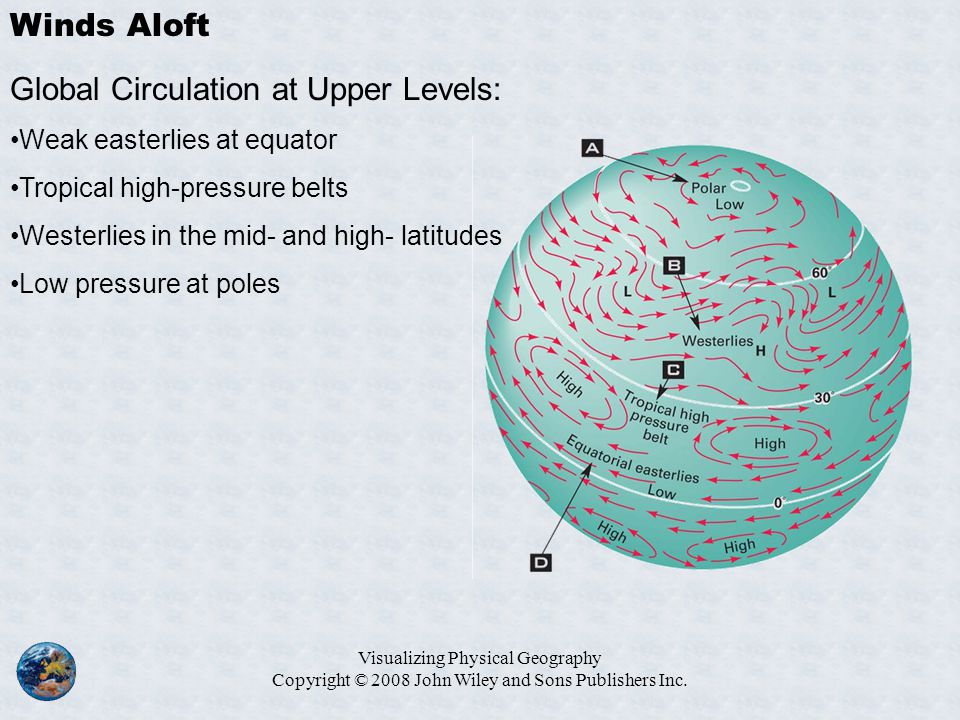
Poleward from the tropical Hadley circulations in the both the hemispheres, air flow in the troposphere is normally and persistently west to east and generally parallel to latitudes as upper air westerlies (Figure 3). These winds around the polar low pressure areas extent up to the entire depth of troposphere because the vertical extent of troposphere is lower as compared with the tropics. The figure 3, shows four major elements of upper air conditions, namely –
(A) polar low;
(B) persistence of upper air westerlies in middle and higher latitudes (here they form a great vortex); (C) tropical high pressure belt, which is constituted by a number of high pressure cells; and (D) equatorial easterlies – between equator and subtropical high pressure cells the upper geostrophic winds are easterly. Similar is the situation in the southern hemisphere. The uniform flow of upper air westerlies is frequently disturbed by the development of large scale undulations, known as Rossby waves. The core part of the Rossby waves with steepest gradients and presence of maximum speed winds in narrow bands represents jet streams.
Figure 3:Upper Air Circulation

Source: http://images.slideplayer.com/14/4279582/slides/slide_18.jpg
Rossby Waves and Index Cycle of Jet Stream
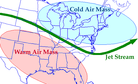
The Rossby waves develop along the narrow polar front zone of contact between two contrasting large bodies of air, cold air mass on the poleward side and warm air mass on the equator-side (Figure 4). These are called Rossby waves because they were discovered first by C.J. Rossby (1937). The direct interaction with their core parts was experienced by pilots of B 29 jet planes of USA during the World War II. The wave length of the Rossby waves is in the range of 2000 to 4000 km, on an average. Therefore, about four to six Rossby waves can be identified around circumpolar region at a time. These waves play a very significant role in determining weather conditions of middle latitudes and are especially associated with genesis of temperate cyclones and anticyclones. The index cycle of jet streams represents the change from straight path to most sinuous path of Rossby waves and jet streams. This transformation takes place in about 4 to 6 weeks and is normally divided into following four successive stages or phases.
Figure 4. Air masses, Rossby Wave and Jet Stream

Source: http://ww2010.atmos.uiuc.edu/guides/mtr/cyc/upa/gifs/jet1.gif
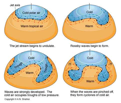
First Stage: In this stage,jet stream prevails near the pole and occupies a general west-east direction. It operates in polar front zone with the presence of cold polar air mass in north and warm tropical air mass in south in northern hemisphere, without any undulations. The polar front in a fairly smooth and stable, which means Rossby waves are absent and path of jet stream is straight (Figure 5). The steep pressure gradient and consequent high velocity jet streams prevail west to east in this strongly established upper air westerly circulation. At this stage near earth surface, in mid and high latitudes westerlies, as planetary winds, are strong, zonal and slightly poleward. This stage is also known as stage of high zonal index. The pressure systems are oriented as zonal, i.e. in east-west direction in particular latitudinal zone.The latitudinal heat exchange is limited and cyclonic activity is prevalent in high latitudes only.
Figure 5: Rossby Waves, Jet Stream Axis and Index Cycle

Source: http://www.crondallweather.co.uk/images/rossby-waves.jpg
Second Stage: In this stage the straight path of jet stream changes to undulating or wavy path which means Rossby waves begin to develop. With the passage of time, the amplitude of the jet stream increases and it starts shifting gradually towards equator. The minor undulations deepen gradually. The cold air makes inroads towards equator south and warm air towards higher latitudes (Figure 5).
Third Stage: In this stage, the path of jet stream becomes meandering and its amplitude registers significant increase. Rossby waves and jet stream moves towards the equator and operate upto 20 latitude. The pressure gradient which was equatorward to poleward in previous two stages becomes west to east in this stage. Large scale latitudinal heat exchanges occur due to movement of cold air mass towards equator and warm air masses towards poles. The cold air makes inroads into lower latitudes in deep embayments, which emerge as troughs of low pressure (L) at high levels. Two such troughs of low pressure are clearly visible in the third diagram (Figure 5). Correspondingly, high pressure ridges are created by the intrusion of tropical warm air in embayments between the troughs. This stage is associated with outbreak of temperate cyclones or wave cyclones near the surface (Figure 6).
Figure 6: Rossby Waves, Jet Streams and Weather conditions over Surface

Fourth Stage: In this final stage of jet stream index, the meanders are at peak and the amplitude of the Rossby waves increases so intensely that large pools of warm tropical air are cut off and isolated in mid and higher latitudes and likewise the large masses of cold air are trapped in lower latitudes. Instead of east-west circulation or zonal, the north-south or meridional circulation predominate. That is why, this stage is also known as low zonal index stage. Many circulation patterns emerge which follow cyclonic pattern in low pressure areas or upper troughs and anticyclonic circulation in high pressure ridges represented respectively by L and H symbols in figures 5, 6 and 7. In this stage of low zonal index north-south contrast of weather conditions and wind speed are minimum. The pressure systems and frontal systems are oriented in meridional position. Therefore, the zonal character of upper-level westerlies gets fragmented into a number of cells.
Figure 7: Upper Troughs and Ridges of Jet Streams and Surface Circulations

It is noteworthy that in this final stage, the detached masses of cold air become cut-off lows, which are cyclones in the upper troposphere. Likewise, warm-air embayments also getdetached to form cut-off highs as upper-air anticyclones. This cut-offs process helps in latitudinal heat transfer and plays a vital role in maintaining the global heat balance. This cut off process takes many days for completion. This transfer or redistribution of heat eventually reduces the thermal gradient and upper air flow becomes flatter and surface weather conditions stabiles. The Rossby waves are formed gradually and it is not necessary that they will move upto the cut-off stage. They may remain stationary for long periods and may dissolve without approaching the cut-off stage. The atmospheric stability and instability (reflected in cyclones) are greatly likedlinked with the Rossby waves and jet streams troughs and ridges. All the four stages of index of jet streams, that is development of Rossby waves to their dissipation, are shown in figure 8, with especial reference to North America.
Figure 8: Development and Dissipation of Rossby Waves over North America

Source: https://image.slidesharecdn.com/atmosphericpressurewindsandcirculationpatterns-170312064522/95/atmospheric-pressure-winds-and-circ

Source: http://www.cengage.com/resource_uploads/downloads/0495555061_137182.pdf
On the basis of understanding of four stages Rossby waves and index of jet streams it can be concluded that wavy flow in upper air is associated with surface weather patterns. During the phases of relatively flat or small amplitude waves the stability prevails and cyclonic activities on surface are very limited. Conversely, when the aloft air flow manifests large-amplitude or curved path having shorter wavelengths, atmospheric instability prevails and is reflected in vigorous cyclonic storms.
Jet Streams: Definition and Characteristics
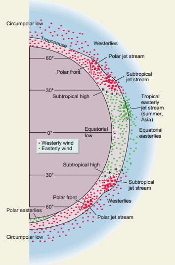
Associated with Rossby waves is a narrow band of very strong winds called jet stream. Jet streams arefound in mid latitude upper troposphere, usually blowing west to east, i.e. as westerlies.These winds attain their highest velocities at 10 to 12 km altitude. The wind velocity is highest at the centre and decreases towards its peripheries (Figure 9). This way it resembles a stream of water moving in a water container. In this figure, the cross section of jet stream shows circular isotachs (line joining equal wind speed) over western United States. The core at the height of about 11 km has the strongest winds at 150 Knots or about 300 km per hour. According to scholar Namias, a jet stream is essentially circumpolar in character, which meanders and completely griddles the earth as upper air westerly in both the hemispheres.
Figure 9: Cross-section of a Jet Stream over Western United States

Generally, jet streams are thousands of kilometers in length, about 150 – 500 km wide and a few kilometers thick vertically. Wind speed in jet streams is on an average about 140 km per hour. They move at an average speed of 110 km per hour in summer and about 190 km per hour in winter. But occasionally, the wind velocities may be about 450 km per hour or slightly more. Over North America wind velocity on an average in a cross section of jet stream is about 60 km per hour in summer and about 125 km per hour in winter. The vertical shear of wind, i.e. the gradient of wind velocity with height is of the order of 5-10 m per second per km. The lateral or horizontal wind shear is about 5 m per second per 100 km. An arbitrary limit on lower side for wind speed along the axis of a jet stream is of 30 m per second. The highest velocities of jet streams are observed in its core region. Generally, as the jet moves from over an ocean to over a continent, its velocity increases due to steeper pressure gradient over land. Conversely, while moving from continent to over an ocean, the velocity normally decreases. Thus, generally highest velocities are recorded over the eastern parts of the oceans and western parts of continents and lowest ones over the eastern margin of continents and western margin of oceans.
Jet streams are characterized by great seasonal shift in positions. With change in overhead position of sun, the jet streams shift poleward in summer and equatorward in winter (Figure 10). In winter the pressure gradients are steep due to intense thermal contrasts and consequently wind velocity is higher in winter about two times that of summer season. Jet streams follow meandering path. In summer season, the crests or ridges of the Rossby waves are located over the continents and the troughs over the oceans. In winter, the continents are under the troughs of the wave while the oceans are under the crests. The seasonal northward and southward shifting is also more conspicuous over the continents than over the oceans. This is mainly due to the differential rates of heating of land and sea.
Figure 10: Seasonal Shifting of Jet Stream

Source: http://nj1015.com/files/2013/03/polar_front_summer_winter1.jpg
Origin of Jet Streams
The origin of winds and its velocity are function of pressure differences which are result of temperature variations. In case of polar jet stream, this temperature variation is result of contrasting cold air mass on polar side and warm air mass on equatorial side of the polar front zone. As cold air is dense and compact than warm air, air pressure decreases at a faster rate in colder air mass as compared to warmer air mass or column of air. It means that north of the polar front zone, there is a higher pressure as compared to its south at one particular altitude (Figure 11).
Figure 11: Pressure Gradient North and South of Polar Front Zone

Source:https://www.eeducation.psu.edu/worldofweather/files/worldofweather/jetstream_reduced.png
As a principle, temperature falls more rapidly in a warm column of air with altitude and pressure falls more rapidly in a column of cold air with altitude. Thus, the fall in pressure with altitude is higher in case of areas of low temperature. Therefore, the fall of pressure north of polar front is steeper than towards its south. In such a situation, an isobaric surface (equal pressure plane in atmosphere) will be sloping towards the area of higher pressure on ground. Also the isobaric surfaces of successively lower pressure will become steeper with higher altitudes (Figure 12).
Figure 12: Isobaric Surfaces and Pressure Gradient Force

Source: http://geography.name/wp-content/uploads/2016/08/34634.jpg
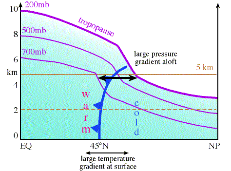
Over the tropical region as temperatures are higher, air pressure decreases more gradually than over the cold polar areas. Consequently, at same altitude above the surface, higher pressure prevails over the tropics and lower pressure over the polar areas. Therefore, the resulting pressure gradient is directed towards areas of high pressure, i.e. tropics towards the areas of lower pressure i.e. polar areas. Thus, thermal contrast at surface results into steep pressure gradient in upper air. The intensity of the thermal contrast is at peak in winter. Therefore, the pressure gradient and resultant jet streams are strongest during winter (Figure 13).
Figure 13: Surface Thermal Gradient Pressure and Gradient Aloft

Due to pressure gradient force,air motion should be from tropics to poleward as indicated by red arrow in figure 14. But the coriolis force also comes into play and counter balances the pressure-gradient force. Therefore, jet stream as a geostrophic wind moves from west to east as upper air westerly.The key aspect in jet stream origin is large thermal contrast at surface produces steep pressure gradients aloft and hence stronger upper air winds as jet streams within the slower, general western flow or as core of Rossby waves.
Figure 14: Pressure Gradient Force, Coriolis force and Jet Stream

Source: http://www.geography.hunter.cuny.edu/tbw/wc.notes/7.circ.atm/westerly.components/westerlies.jpg
Types and Distribution of Jet Streams
On the basis of their location or distribution, jet streams are classified into following three types.
Polar Jet Stream
Subtropical Jet Stream
Easterly Tropical Jet stream
Stratospheric Subpolar Jet Streams Local or Regional Jet Streams
(i) Polar Jet Stream: It is also known as polar front jet stream because it is associated with polar front. Polar fronts are linear zones which occur due to large thermal gradient created by convergence of contrasting cold air mass of polar areas and warm or mild air mass of tropical areas. It occurs near tropopause between polar cell and Ferrel cell (Figure 15). As explained in the origin of jet stream, this surface thermal contrast results into pressure gradient in upper air and jet streams blow at high velocity from west to east. As this jet stream originates and prevails in mid latitudes it is called mid-latitude jet stream also. They are most active at 300 mb that is at altitude of about 9 km, within 40-60 latitudes. The seasonal shifting is in the range of 30 to 70 degree of latitudes in both the hemispheres. At occasions, especially in northern hemisphere, it is in discontinued bands instead of circumpolar continuous band. At other occasions, especially in winter it is more intense and more organized consisting of a succession of velocity maxima, alternating with bands of weak winds (Figure 16)
Figure 15: Polar Jet Steam

Source: http://www.srh.noaa.gov/jetstream/global/images/jetstream3.jpg
Figure 16. Polar Jet Stream

Source: http://www.srh.noaa.gov/jetstream/global/images/jetstream2.jpg
(ii) Subtropical Jet Stream: It is also known as subtropical westerly jet stream. It is second jet stream of major significance in the global air circulations in the subtropical latitudinal zone. It occupies a position at the tropopause between Hadley cell and Ferrel cell, at the altitudinal range of 9 to 13 km (Figures 15 and 16). In case of this jet stream, the front of contrasting air masses is not present and surface thermal gradient is also very poor. Its origin is related to a thermal gradient confined to the upper tropopause. In comparison to polar jet stream it is much more persistent. Generally, they are weaker than the mid latitude jet streams but occasionally they are as strong as polar jet streams.
(iii) Easterly Tropical Jet stream: It forms in the upper troposphere over India and Africa in summer monsoon season only due to regional reversal of the south-north temperature gradient. They are associated with intense heating of Tibetan Plateau during monsoon season. Generally, they blow at 100 to 180 km per hour velocity. The tropical easterly jet stream is limited to summer season and northern hemisphere only. This jet stream occupies position at very high altitude,e. about 15 km. It is located over the Hadley Cell (Figure 17). It plays a significant role in monsoon mechanism. The extent of monsoon season in Southeast Asia is associated with its presence.
Figure 17: Tropical Easterly Jet Stream

Source:http://2.bp.blogspot.com/-46X-VkpdJtg/U3G9XGi6MfI/AAAAAAAAASQ/ujee82tvgto/s1600/Jet+Streams.PNG
(iv) StratosphericSubpolar Jet Streams:These are also known as Polar night Jet streams. They originate in stratosphere at an altitude of about 30 km around the poles in winter season (Figure 18). Due to steep thermal and pressure gradients they move as westerlies at very fast speed in winter, but in summer they are weak and easterly.
Figure 18: Polar Night Jet Stream

Source: https://media1.britannica.com/eb-media/77/7577-004-AEDCC94C.jpg
(v) Local or Regional Jet Streams:Over the period of time due to better data acquisition techniques scholars have identified many local or regional jet streams of temporary nature, for instance, Somali jet stream (Figure 19). They originate due to local level thermal contrasts and dynamic changes in upper troposphere. These have significance in influencing the local weather conditions.
Figure 19: Distribution of Jet Streams: Permanent and Temporary

Significance of Jet Streams
Although weather scientists are not yet fully aware about the origin, forms and features of different types of jet streams yet they have been able to establish relationship of jet streams with many surface weather phenomena. The most well understood and well established relationship is between jet streams and mid latitude temperate cyclones in the belt of westerlies. The troughs and ridges of Rossby waves and jet streams are associated with cyclonic and anticyclonic conditions in upper air as well as on surface (Figures 6 and 7). Temperate cyclones and associated precipitation is above normal whenever upper air jet streams are positioned over cyclones. The index cycle of jet streams results into latitudinal heat transfer between tropics and mid latitudes and plays a significant role in global heat balances (Figures 5 and 8).
Jet streams play a very significant role in monsoon mechanism. The onset of monsoon is directly associated with northward shifting of subtropical westerly jet stream. Subtropical jet stream occupies position over the Great Plains of India in winter season. Till the time jet stream prevails over this area, it maintains a pressure gradient from north to south and this is not in favour of onset of southwest monsoon over India. Therefore, the shifting of subtropical jet stream north of Himalayas is prerequisite for the established of Hadley cell over Indian subcontinent. In summer season, the temporary tropical easterly jet stream also plays significant role in monsoon mechanism because it tends to strengthen the summer monsoon. Subsiding air on its left margin creates a high pressure over the Bay of Bengal and the Indian Ocean, while rising air under its right margin causes low pressure under its right margin over the Great Plains region. Therefore, it helps in enhancing the south to north pressure gradient steeper. Hence, it is associated with the strength and length (duration) of southwest monsoon season. Subtropical westerly jet streams bring western disturbances in North West India during winter season. This results in precipitation in north India during winter season. Jet streams also play an important role in the movement of air masses and associated weather changes in the trajectory. Thus, it is well established that jet streams play a significant role in surface weather phenomena.
Summary and Conclusions
Temperature, atmospheric pressure and air circulations are quite different in upper part of troposphere as compared with those prevailing near the earth’s surface. In middle and higher latitudes of both the hemispheres upper air westerlies prevail due to balancing act of pressure gradient force and coriolis force. The uniform flow of upperair westerlies is frequently disturbed by the development of large scale undulations, known as Rossby waves. The core part of the Rossby waves with steepest gradients and presence of maximum speed winds in narrow bands represents jet streams.The index cycle of jet streams represents the change from straight path to most sinuous path of Rossby waves and jet streams. This transformation takes place in about 4 to 6 weeks and is normally divided into four successive stages or phases.
In jet stream wind velocity is highest at the centre and decreases towards its periphery. This way it resembles a stream of water moving in a water container. Generally, as the jet moves from over an ocean to over a continent, its velocity increases due to steeper pressure gradient over land. Conversely, while moving from continent to over an ocean, the velocity normally decreases. Jet streams are characterized by great seasonal shift in positions. On the basis of their location or distribution and influence of weather conditions three main jet streams are – (i)Polar Jet Stream, (ii) Subtropical Jet Stream, and (iii) Easterly Tropical Jet stream.
Although weather scientists are not yet fully aware about the origin, forms and features of different types of jet streams, yet they have been able to establish relationship of jet streams with many surface weather phenomena. The most well understood and well established relationship is between jet streams and mid latitude temperate cyclones in the belt of westerlies. The index cycle of jet streams results into latitudinal heat transfer between tropics and mid latitudes and plays a significant role in global heat balances. Jet streams both subtropical westerly as well as easterly play a very significant role in monsoon mechanism. Jet streams also play an important role in the movement of air masses and associated weather changes in the trajectory. Thus, it is well established that upper air circulations play a significant role in surface weather phenomena.
| you can view video on Upper Air Circulation: Jet Streams, Origin, Types and Distribution |
References
- Barry, R.G. and Chorley, R.J. (1998) Atmosphere, Weather and Climate, Routledge, London.
- Critchfield, H.J. (1983) General Climatology, PHI Learning Private Limited, New Delhi.
- Frederick, K.L and Edward, J.T. (2010) The Atmosphere – An Introduction to Meteorology, PHI Learning Private Limited, New Delhi.
- Khullar, D.R. (2012) Physical Geography, Kalyani Publishers, New Delhi.
- Lal, D.S. (1993) Climatology, Chaitanya Publishing House, Allahabad.
- Lal, D.S. (2009) Physical Geography, Sharda PustakBhawan, Allahabad.
- Oliver, J.E and Hidore, J.J. (2003) Climatology: An Atmospheric Science, Pearson Education, Delhi.
- Singh, S. (2015) Physical Geography, Pravalika Publications, Allahabad.
- Strahler, A.N. and Strahler, A.N. (2001) Modern Physical Geography, John Wiley and Sons, Singapore.
- Trewartha, G.T. and Horne, L.H.(1968) An Introduction to Climate, McGraw-Hill, New York.
Web Links
- https://www.atmos.illinois.edu/~snodgrss/Jet_stream_files/image001.jpghttp://geography.name/ wp-content/uploads/2015/09/FIG06_013- 640×327.jpghttp://images.slideplayer.com/14/4279582/slides/slide_18.jpg
- http://ww2010.atmos.uiuc.edu/guides/mtr/cyc/upa/gifs/jet1.gif
- http://www.crondallweather.co.uk/images/rossby-waves.jpg
- https://icons.wxug.com/hurricane/steveg/ANS3.png
- https://www.atmos.illinois.edu/~snodgrss/Jet_stream_files/image001.jpg
- https://image.slidesharecdn.com/atmosphericpressurewindsandcirculationpatterns-170312064522/95/atmospheric-pressure-winds-and-circulation-patterns-17-638.jpg?cb=1489301154
- http://www.srh.noaa.gov/jetstream/global/images/jetctrosssection.png
- http://nj1015.com/files/2013/03/polar_front_summer_winter1.jpg
- http://geography.name/wp-content/uploads/2016/08/34634.jpg
- http://apollo.lsc.vsc.edu/classes/met130/notes/chapter10/graphics/pf_xsect2.free.gif
- http://www.geography.hunter.cuny.edu/tbw/wc.notes/7.circ.atm/westerly.components/westerlies.jpg
- http://www.srh.noaa.gov/jetstream/global/images/jetstream3.jpg
- http://www.srh.noaa.gov/jetstream/global/images/jetstream2.jpg
- http://2.bp.blogspot.com/-46X-VkpdJtg/U3G9XGi6MfI/AAAAAAAAASQ/ujee82tvgto/s1600/Jet+Streams.PNG
- https://media1.britannica.com/eb-media/77/7577-004-AEDCC94C.jpg
- http://www.goes-r.gov/users/comet/tropical/textbook_2nd_edition/media/graphics/major_indian_circulations.jpg
- http://www.cengage.com/resource_uploads/downloads/0495555061_137182.pdf