20 FRONTOGENESIS PROCESS: WORLD PATTERNS AND ASSOCIATED WEATHER
Dr. Prabuddh Kumar Mishra

Objectives
- define fronts, identify the frontal zones,
- discuss characteristics of fronts,
- explain the classification of fronts,
- distinguish between cold and warm front, and;
- describe the distribution of fronts over the globe and weather phenomena
Introduction
Learning Objectives
Definition of Front
Frontal Zone
Frontogenesis
Conditions for Frontogenesis
Temperature Difference
Convergence of Air Masses
Development of Fronts
Frontolysis (Dissipation of Fronts)
Frontal Characteristics
Classification of Fronts
Warm Front
Cold Front
Stationary Front
Occluded Front
Cold Occlusion
Warm Occlusion
World Distribution Pattern of Fronts
Associated Weather with Warm Front
Associated Weather with Cold Front
Summary and Conclusion
Multiple Choice Questions
Answer to MCQs
References
Web References
Introduction
The literal meaning of the term ‘front’ is the forward margin of something. It a sort of boundary between two air bodies. These two bodies are quite different from each other. It is not always possible to find definite boundaries between two different air masses. More often a gradual transition is observed for many kilometers. However when one air mass moves rapidly into another a distinct boundary becomes established. Such a boundary is called a front. Therefore, it can be stated that a narrow strip along two different bodies is generally termed as front. Another word ‘genesis’ means beginning or method of formation or evolution of something. You must be aware that the air mass is divided into different groups based on different criteria. When two different bodies of air masses are coming into direct contact with each other, fronts are originated. Therefore, the process of the formation of front is known as frontogenesis. Frontogenesis is very commonly found in the higher latitudes. They have evolved a unique pattern over the globe and have modified the weather of the area under their influence very significantly. Opposite to frontogenesis, there is term called ‘frontolysis’ meaning the decaying of fronts. In this module, an attempt is made to study the process of the formation of fronts, their distribution as well as associated weather conditions.
Definition of Front
Fronts are three dimensional sloping boundary across which the horizontal gradients are sleek. In other words, fronts are defined as ‘zone of mixing’ or ‘discontinuity between two air masses’. They have contrasting characteristics in terms of temperature, density, relative humidity, wind direction, and pressure. Fronts are interface between cold and warm air masses interacting along the temperate convergence zone or subtropical low which help maintaining latitudinal heat balance. Thus, it can be said the front is a line of discontinuity that represents the transitional zone between two air masses having contrasting characteristics. Frontal surface separates these two contrasting air masses.
The first real advancement in our understanding of the mid-latitude weather variations was made with the discovery that many day-to-day changes are associated with the formation and movement of boundaries or front, between air masses. The term ‘front’ was first proposed by a group of meteorologists which was led by Vilhelm Bjerknes who was working in Norway, during the First World War in 1918. The three meteorologists V.J. Bjerknes, H. Solberg, and T. Bergeron are considered important for creating an in-depth knowledge and advancement of the fronts. Their ideas are still a very integral part of the forecasting and weather analysis in the middle and the high latitudes. Later, in 1975 F.W. Cole defined fronts as an interface or transition zone between two air masses of different density. However, it should be noted that fronts are not only the transition zone between two air masses of different density. The transition zone might also be of different temperature, humidity, wind direction, and pressure.
Frontal Zone
Frontal zone is the vast transitional zone between two converging air masses. It depicts the discontinuity zone of opposing and contrasting air masses. Frontal zones are inclined at a very low angle towards the ground and are never parallel or vertical to the ground surface. Frontal zone is a dynamic and mobile zone, therefore it drifts with prevailing winds.
Frontogenesis
The term frontogenesis was introduced by Tor Bergeron (Norwegian meteorologist) for describing the formation of new fronts. However, later the term was extended to include the process of formation of both new fronts and the regeneration of the old and decaying fronts that already exists in the atmosphere. The region of frontogenesis represents the region that has the convergence of the contrasting air masses. On contrary, we use the term frontolysis means the destruction or dying of fronts. Hence, frontolysis is the opposite of frontogenesis. Fronts do not come into existence all of a sudden; rather they appear only after the process of frontogenesis has been in operation for quite some time. The act of weakening or vanishing of the existing fronts is not accompanied suddenly. The process of frontolysis must continue for some time in order to destroy an existing front.
Conditions for Frontogenesis
When the distribution of frontogenesis was studied, it was noticed that this process doesn’t occur everywhere. Frontogenesis requires certain characteristics for processes to occur. They are: Temperature Difference: The two opposing air masses that converge to form a front must have a contrasting temperature. If one air mass is warm, moist and light, a front can only be created when the other air mass is cold, dry and dense. What happens when these two contrasting air masses converge? The cold and dense air mass obviously invades the area occupied by the warm and light air mass. As a result, the warm and light air mass is pushed upward and this generates a front. This also explains why no frontogenesis takes place in the equatorial region. Two air masses also converge at the equator (trade winds) but the temperature of both these air masses is uniform. So, the temperature difference is the missing factor here because of which no frontogenesis takes place at the equator.
Convergence of Air Masses: In the very definition of frontogenesis, the word ‘convergence’ has been used and thus it is understood that it is the pre-requisite for the frontogenesis process. When two air masses having different temperature converge, they try to invade the space of each other and this leads to the formation of the fronts. For frontolysis to occur, the air masses have to diverge or get diluted by mixing and the contrast being removed.
Development of Fronts
When two contrasting air masses converge and spread horizontally along the axis of dialation, the probability of creation of front increases. However, there are other necessary conditions for the actual formation of the frontogenesis. When the convergence occurs, the formation of the fronts depends on the angle between the axis of dialation and the isotherms. Fronts are not formed when this angle is more than 450. Frontogenesis is only activated when the angle between the axis of dialation and isotherms decreases. Due to this decrease in angle, a point comes when the isotherms become almost parallel to the axis of dialation and this is when the frontogenesis takes place.
The intensity and steepness of the front depend on the temperature gradient of the two air masses. A stationary front is formed when convergence between two air masses parallel to each other occurs. In such a situation, no upward displacement of the air occurs. Such kind of stationary front doesn’t result in cloud formation and precipitation. Stationary fronts are rarely formed because a slope mostly occurs in the fronts due to the Coriolis force.
Frontolysis (Dissipation of Fronts)
Frontolysis (frontal decay) represents the final phase of a front’s existence, although it is not necessarily linked with occlusion. When contrasting air masses lose their characteristics and difference decay occurs. In other words, when the air masses move away from each other or when the temperature contrast between the adjacent air masses diminishes due to one reason or another the fronts dissipate or start declining.
The dissipation of fronts takes place in three ways: (a) through front’s stagnation over a similar surface; (2) as a results of both the air masses cold and warm moving on parallel tracks at the same speed; (3) by the system entering air of the same temperature. Frontolysis happens in the area of Siberia, Northern America etc.
Frontal Characteristics
The character of frontal weather depends upon the vertical motion in the air masses. If the air in the warm sector, it is rising relative to the frontal zone. The fronts are very active and are termed ana-fronts. The term “ana-front” describes boundaries which show instability, meaning air rises rapidly along and over the boundary to cause significant weather changes. Sinking to warm air relative to cold air masses gives rise to less intense Kata-fronts (Berry et at., 2010 pp-238). “Kata-front” is weaker, bringing smaller changes in temperature and moisture, as well as limited rainfall. Fronts may differ in their types, location or a real extent, but the following characteristics are more or less common to all of them.
Fronts are the zone of mixing of cold and warm air masses and it covers certain area. The area and extent which is covered by the fronts vary in time and space ranging from 3D boundary extending up to tropopause.
Apart from area, slope is one of the most important characteristics of the front. In general, cold fronts are steeper than warm fronts. The frontal slope depends upon latitude of the front, wind speed, and temperature difference between the air masses. Cold air always run under the warm air, when the slope between them is steep, the large vertical motion will occur because of the intense lifting of warm air mass. This will result in intense weather. The factors which are responsible for steeper slopes are large wind velocity, difference between air masses, temperature difference and latitude.
Isobars and isotherms develop ‘kink’ (bend) in the frontal zone. Because of an abrupt change in pressure as well as pressure gradient across a front, the isobars while crossing it from a kink and always bend towards the direction of low pressure. The wedge formed by the bending of isobars across a front always points towards the higher pressure. Mostly the fronts lie in the trough of low pressure. Temperature is the principal property used to identify air masses and fronts between them. Large differences in air temperature are recorded across a front. But the changes in temperature may be abrupt or gradual depending on the nature of opposing air masses. Further, the width of the frontal transition zone is dependent on the temperature contrast between two air masses. Larger the difference in temperature, thinner the frontal zone and vice versa. Fronts are always characterized by temperature inversion layer because of the warm air over a wedge of cold and dense air masses. Inversion of temperature is found in the frontal zone, warm air override the cold air.
Winds always blow from higher to lower pressure crossing the isobars at an acute angel as wind movement is always controlled by pressure gradient and Coriolis force. It is, therefore, natural that an abrupt wind shift must occur at the fronts. On common parlance it can be stated that sudden shift in the direction of wind is observed (i.e. wind direction is not fixed). The frontal intensity is determined by the turbulence. Both turbulence and gustiness are required to make the front strong. Gustiness results into convective phenomena like strong winds and thunderstorm.
Frontal activity is invariably associated with cloudiness and precipittion. Since warm air moves up along the frontal surface, it cools adiabatically which results in cloudy condensation and precipitation. The type of clouds and precipitation falling from them depend on the slope of the front and the amount of moisture in scending mass of air. The weather condition is also affected by the speed of the front. The rapidly moving fronts create intense weather conditions in comparison to slower moving fronts. Fronts are the agents of latitudinal exchange of heat and moisture as frontal zone is a mobile zone therefore it drifts with prevailing winds. Fronts are favorable place for cyclogenisis and have generally a life cycle of 4 to 7 days after that they start decaying.
Classification of Fronts
The types of front depend on the characteristics of the front, direction of the movement of the air mass, mechanism of frontogenesis and associated weather. Fronts are classified into four main types (Figure. 1):
The Warm Front The Cold Front
The Stationary front The Occluded Front
Warm Front
A warm front is that gentle sloping frontal belt along which the warm air moves over the area which has been occupied by the cold air and the cold wedge present in the frontal zone retreats. The average slope of the warm front in the middle latitude is 1:100 to 1:400. The warm air that has risen above then cools down adiabatically and then it becomes saturated and gets condensed. Later, it causes gentle precipitation in a large area for a long period of time. The frontal boundary of such front has a very gentle slope. They move slowly and are less violent in nature in comparison to a cold front. They may result in thunderstorms but most of the time they are associated with strati form clouds that bring light to moderate rainfall. Before the arrival of such fronts, one can see the arrival of cirrus clouds, altostratus cloud, altocumulus cloud and finally the stratus cloud and the fogs.
Figure 1: Types of Fronts

Source: https://socratic.org/questions/what-are-the-main-types-of-fronts
Cold Front
A cold front is formed when the cold air mass in the frontal zone moves under the warm air mass. Along the slope of this front, the cold air gets active and it invades the territory of the warm air. The cold air being the dense air settles downs and forces the warm air to uplift. The slope of the cold front is 1:50 to 1:100. The weather conditions associated with a cold front is a bad weather that brings with it thick clouds, heavy precipitations, thunderstorms, and lightning. The slope of a cold front is much steeper than the warm front. These are the fastest moving front and it is associated with the most violent kind of weather conditions. Also, these cold fronts travel the farthest by maintaining its intensity. The arrival of a cold front is marked by the arrival of cirrus cloud before them. The cold fronts are also associated with the squall lines which are basically lines of thunderstorms that run parallel to and ahead of the front.
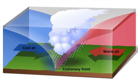
Stationary Front
Stationary front is formed when two air masses converge in a manner that they are parallel to each other (Figure 2). As a result of this parallel placement, no vertical movement of the air takes place in stationary front. It can be guessed from the name itself, that stationary front neither travels forward nor backward. It remains stationary in its position. Their behavior is similar to warm air but is much calmer than them. Stationary fronts are formed rarely because due to Coriolis force, most of the type a slope is created before the formation of a front. These fronts mostly occur over the ocean sea.
Figure 2: Formation of Stationary Front

Source: https://www.pmfias.com/wp-content/uploads/2016/01/stationary-front-.jpg
Occluded Front
It is earlier stated that cold front travels the fastest among all the fronts. Occluded fronts are created when while traveling the cold front overtakes the warm fronts and the warm air is totally displaced from the ground surface. The mature storm system is associated with it. An occluded front is further classified into two kinds of fronts (Figure 3).
Figure 3: Occluded Front

Source: https://meteoplaneta.rs/wp-content/uploads/2011/04/FIG10_001E.jpg
Cold Occlusion: Cold occlusion front occurs when the cool air that is present behind the cold front is colder than the advancing cold air which is present ahead of the warm front. Such kind of occlusion can mostly be seen in North America. This occlusion occurs when the cold front forces itself under the warm front and as a result of that uplifts the warm front.
Warm Occlusion: Warm occlusion occurs when the air which is present behind the cold front is warmer than the advancing air which is present ahead of the warm front. In simpler terms, it can be understood as warm occlusion occurs when the cold air which is present behind the cold front is not dense enough to lift the cold air which is present ahead of the warm front. Here, the retreating air overtakes the advancing air. It is uncommon to find warm occlusion in comparison to cold occlusion.
World Distribution Pattern of Fronts
Fronts and associated depressions tend to develop in a well defined order. The major regions of frontal development are the areas that are most frequently baroclinic as a result of air stream confluence. This is in the case off East Asia and Eastern North America, especially in winter, where there is a sharp temperature gradient between the snow covered land and warm offshore currents. These zones are referred to as Pacific Arctic Fronts (formed along the Rockies-Great Lakes region) and Atlantic Polar Front (formed when maritime tropical air masses meet continental polar air masses. Full development of this front takes place during winter) respectively. There position is quite variable, but they are displaced equator ward in winter, when the Atlantic Frontal Zone may extend into the Gulf of Mexico. Here there is mixing of different characteristics of air masses in terms of stability between subtropical high pressure cells. Depressions developing here commonly move northeastward. Frontal frequency is very high in North Atlantic whereas it decreases eastward in the North Pacific because of less gradient of sea surface temperature. Frontal activity is also very common in Central North Pacific.
Another section of the Polar Front, commonly referred to as the Mediterranean Front located over the Mediterranean-Caspian Sea areas is formed when the cold polar air masses of Europe meet the winter air masses of North African origin over Mediterranean basin and initiates frontogenesis. In the summer because of the anti-cyclonic conditions the frontal zone is absent. The Atlantic Arctic Front is formed when the maritime polar air masses meet the air masses developed along the boundary of Arctic source- region. Some of the important front formed during January and July are presented in figures 4 and 5 respectively.
Figure 4: Major Fronts Formed During January

Figure 5: Major Fronts Formed During July

Source: http://www.yourarticlelibrary.com/geography/fronts-formation-characteristics-and-classification-of-fronts/42215/
Associated Weather with Warm Front
Warm front produces a variety of weather phenomena (Table 1). The warm front, with rising warm air, has multi-layered clouds that thickens and lowers towards the surface positions of the fronts. Clouds are deepest just north of the warm front boundary and progressively becomes thinner and higher toward the north. High wispy cirrus is present in the form of “mares’ tails” appear first, then progressively thick and lower clouds like cirrostratus, altostratus, nimbostratus appears as the front approaches (Figure. 6). The Sun is obscured as the altostratus layer thickens and drizzle begins to fall. The cloud often extends through most of the troposphere and, with continuous precipitation occurring, is generally designated as nimbostratus. The intensity of the precipitation depends on the stability of the warm air. It is generally light to moderately heavy and continues extending over a wide zone. If the warm air is conditionally unstable, thunderstorms may develop over the warm front. In addition, fogginess and poor visibility are very common on the precipitation area. At the passage of the warm front the wind veers, the temperature rises and the fall of pressure is checked. If the temperature in the cold air is below freezing, snow, ice pellets, or freezing rain may occur. As the front passes, an appreciable rise in temperature is observed.
Figure 6: Satellite Image with Some Fronts and clouds

(Source: https://bmtc.moodle.com.au/mod/book/view.php?id=3768&chapterid=2324)
Associated Weather with Cold Front
Cold front also produces a variety of weather conditions and phenomena that are equally variable, depending upon the stability of the warm sector air and the vertical movement of the frontal zone (Table-1). The classical cold front clouds are accompanied by cumulonimbus with vertical development and heavy showery precipitation. Over the British Isles, air in the warm sector is rarely unstable, so that nimbostratus occurs more frequently at the cold front. With the cold front the cloud is generally stratocumulus and precipitation is light. With cold fronts the precipitation is generally for short periods but it is very heavy downpour. Many a times precipitation is accompanied by thunderstorms.
Table 1: Changes Associated with Warm and Cold Fronts

In Northern Hemisphere there will be a wind shift from a southerly or southwesterly direction to the northwest or north at its passage. With the passage of the cold front the wind veers sharply and pressure began to rise and there is fall in temperature. A drop in temperature is expected after the passage of cold front. Within a few hours of passing the front, clearing of skies can be expected. Since the cold air mass moves over warmer ground, sufficient instability may develop in its lower layer to produce scattered shower. If the precipitation is snow, the combination of low temperature, strong winds and blowing snow along and following the cold front is called a Blizzard in North America and Buran in Siberia.
Summary and Conclusions
The most significant and prime contribution was made by Tor Bergeron with his team. He was the one who first proposed the term front for first time. When two air masses with different physical properties meet, due to effect of the converging atmospheric circulation, they do not merge readily. The transition zone or the layer of discontinuity so formed between two air masses is a three dimensional surface called front. The fronts can be classified in four types viz: cold, warm, occluded, and stationary front. Warm front produces a variety of weather phenomena. The associated weather phenomena are different in each type of fronts. The cold front brings lots of precipitation and cold weather whereas the warm front is brings drizzly rain and warmer weather. Stationary front is where they come together and they stay stationary, or not moving, and you’re going to get cloudy, wet and weather.
Fronts and associated depressions tend to develop in a well defined order. The major regions of frontal development are the areas that are most frequently baroclinic as a result of air stream confluence. The major areas for frontogenesis are Pacific Arctic region, Atlantic Polar region and Mediterranean region. Much is being studied about the fronts but still we lack precision in forecast and assessing their intensity. It is a process through which heat exchange takes place. Now a day’s availability of satellite imageries and data has helped in better understanding of frontogenesis. Fronts are of crucial importance in determining the well being of human and society.
| you can view video on FRONTOGENESIS PROCESS: WORLD PATTERNS AND ASSOCIATED WEATHER |
References
- Aguado, E. and J.E. Burt. 2004. Understanding Weather and Climate. 3rd Edition. Prentice Hall, Upper Saddle River, New Jersey.
- Ahrens, C.D. 2003. Meteorology Today: An Introduction to Weather, Climate, and the Environment. 7th Edition. Thomson Learning.
- Allegre, C.J. and S.H. Schneider 1994. The evolution of the earth. Scientific American Oct.: 66-75.
- Barry, R.G., R.J. Chorley, and N. J. Yokoi. 2010. Atmosphere, Weather, and Climate. 9th Edition. Routledge, London.
- Craghan, Michael. 2003. Physical Geography: A Self-Teaching Guide. New Jersey: Jhon Wiley & Sons, Inc.
- Elsner, James B. and A. Birol Kara. 1999. Hurricanes of the North Atlantic. Oxford University Press. Falkowski, P.G. 2002. Ocean’s invisible forest. Scientific American Aug.: 53-61.
- Strahler, Alan H. and Arthur Strahler. 2003. Physical Geography: Science and Systems of the Human Environment. 2nd Edition. John Wiley and Sons, New York.
- Strahler, Alan, and Zeeya Merali. 2008. Visualizing Physical Geography. New Jersey: JohnWiley & Sons, Inc.
- Strahler, Alan. 2011. Introducing Physical Geography. New Jersey: John Wiley & Sons, Inc.
- Sturm, M., D.K. Perovich, and M.C. Serreze. 2003. Meltdown in the north. Scientific American Oct.: 60-67.
Web References
- http://www.physicalgeography.net/fundamentals/7s.html
- http://www.yourarticlelibrary.com/geography/fronts-formation-characteristics-and-classification-of-fronts/42215/)
- https://bmtc.moodle.com.au/mod/book/view.php?id=3768&chapterid=2324
- https://meteoplaneta.rs/wp-content/uploads/2011/04/FIG10_001E.jpg
- https://socratic.org/questions/what-are-the-main-types-of-fronts
- https://www.pmfias.com/wp-content/uploads/2016/01/stationary-front-.jpg