26 DRY CLIMATES: SEMI ARID AND ARID
 Contents
Introduction
Learning Objectives
Meaning of Tropical Climates
Semi Arid Climates
Distribution
Temperature
Rainfall
Vegetation
Animal Community of Temperate Grasslands
Temperate Grasslands and Human Interactions
Arid Climates
Distribution
Temperature
Pressure and Winds
Rainfall
Natural Vegetation
Animal Community
Human Activities
Summary and Conclusions
Multiple Choice Questions
Answer of MCQs
References
Web Link
Introduction
The average weather conditions like temperature, precipitation, humidity, air pressure, cloudiness, winds etc. over a long period of time are called climate. The variations in the average climatic conditions have great departures. Depending upon the departure numerous types of climates over the globe are found. A set of average weather conditions determine the nature or type of a climate of any region. Temperature and precipitation are the major variables which influence the vegetation of any area. Vegetation influences the fertility of the soil as well as the economic activities of the people. The animal community and human life is also influenced by the climate. Change in amount of these two very important variables, develops a separate biome. Distribution of world climates indicate towards a sequence of climatic appearance. They are primarily guided by both factors – temperature and precipitation. One such climatic division is Dry (Semi and Arid) climates. We will try to concentrate on this type of climate in this module.
Learning Objectives
After studying this module, you will be able to:
- distinguish between semiarid and arid climate,
- understand the various characteristic features of semi arid grasslands of the world,
- find out the relationship between the growth of grasslands and the human activities,
- explain the role of relief features as a barrier in the formation of a desert land, and
- discuss the adaption of vegetation and animals in arid climate.
Meaning of Dry Climates
The climates where evaporation exceeds precipitation faces scarcity of water. It happens due to more temperature. High temperature increases, the capacity of the air to hold water. Therefore, more evaporation and transpiration are initiated. This reduces the amount of moisture in the soil and cause the retardation in the growth and development of vegetation in that region. The primary characteristic of a dry climate is low and unpredictable precipitation (less than 70cm per year). If the amount of rain is less than 35 cm, it is called desert and where the precipitation varies from 35 to 70 cm, it is categorized as semiarid. Another characteristic of the dry climate is more coefficient of rainfall variability with great seasonal as well as daily range of temperature.
These climates are divided into two types on the basis of annual precipitation e.g. (1) dry desert climate (BW) and (2) semi arid climate (BS). The term ‘B’ refers for xerophytes types of vegetation. In another words, ‘B’ refers to desert type of climate. The term ‘W’ is used for the land which is almost of no use economically. In another words, it is a waste land. The dry/ desert climate is further classified on the basis of annual temperature. When the mean annual temperature is more than 18°C, the climate is considered to be hot and it is termed as ‘h’ letter. When annual mean temperature is less than 18°C, it is shown by ‘k’ letter which means cool. In this way dry climates are divided into four sub types e.g. (1) BWh (Tropical hot desert climate), (2) BSh (Tropical semiarid/steppe climate), (3) BWk (mid latitude cold desert climate) and (4) BSk (mid latitude cold steppe climate. Out of the four climatic divisions mentioned here two (BWh and BWk) belong to the arid and the other two (BSh and BSk) to semi arid climates.
Semi Arid Climates
The areas receiving mean annual rainfall between 35 to 70 cm come under the category of semi arid climates. These climates are depicted through the group of letters (BSh) and (BSk) where BS stands for semi arid ‘h’ for hot and ‘k’ for cold. BSh climates (tropical and subtropical) are found in the belt of dry trade winds and subtropical anticyclones. BSk climates are confined to the anticyclonic conditions (temperate steppe) by cold anti cyclones during winter season. Hot semi arid climates are located bordering a humid subtropical or tropical savanna climates depending upon the amount of rain. These climate are hot, sometimes extremely hot with warm to cool winters and minimal precipitation. The middle latitude steppe climate (BSk) is extended over the vast temperate grasslands providing ideal conditions for grazing grounds and the related economic activities.
Distribution
Temperate grasslands are located in the interiors of the continents in the northern hemisphere. These areas come in the westerly wind belt yet they do not get sufficient rainfall. In the southern hemisphere these grasslands are located along the south eastern margins of the continents with more moderate climate because of the marine influence. These grasslands are known with different names in different areas of the world. In Europe these are known as ‘Steppes’ extending more than 3200 km. from the shores of ‘Black Sea’ to the foothills of ‘Altai Mountains’ with broken continuity at few places by the highlands. Some isolated patches of these grasslands are known as ‘Pustaz’ in Hungry and ‘Manchurian grasslands’ in plains of Manchuria. These grasslands in North America are known as, ‘Prairies’ which extend from Canada to USA and from the foothills of the Rockies in the west to the margins of deciduous forest in the east. In the southern hemisphere these grasslands are known as ‘Pampas’ in Argentina and Uruguay (South America), ‘Bush Veld’ and ‘High Veld’ in South Africa, ‘Downs’ in the ‘Murray Darling Basins’ of Southern Australia and ‘Canterbury grasslands’ in New Zealand. The distribution of the semi-arid and arid is shown in Figure 1.
Figure 1: World Distribution of Arid and Semi Arid Climates

Temperature
The temperate grasslands are influenced by the continental effect. These areas are warm in summer days but experience very cold condition during. Winter. The average maximum temperature at Winnipeg (Canada) is as high as about 250 C in summer but the same place is about minus 250 C during winter. The annual range of temperature is around 500 C which is very high. The excessive low temperature in winter is due to continental type of climate. These areas are far away from the moderating effect of coastal areas. The semi-arid areas of southern hemisphere is relatively low annual range of temperature. It is because of narrower landmass in the southern hemisphere, hence, effect of ocean is a bit more. The diurnal range of temperature is more in this climate. The monthly maximum and minimum is temperature recorded at Winnipeg, Canada is presented in the Figure 2. A big departure in these figures are very much perceivable.
Figure 2: Monthly Maximum and Minimum at Winnipeg, Canada

Source: http://www.eldoradocountyweather.com/canada/climate/winnipegclimate.html
Rainfall
Temperate grasslands receive most of its annual rainfall during summer season and some amount of winter precipitation is received in northern hemisphere usually in form of snowfall. The mean annual rainfall here ranges between 35 cm to 70 cm with a marked regional variation. Eurasian steppe climate occupies the largest area of all the grasslands. It receives mean annual precipitation ranging from 30 to 60 cm. This area is grouped into four different divisions. These are forest steppe (50 to 60 cm), meadow steppe (35 to 50 cm) and the other two areas are grass and xeromorphic steppe where the precipitation ranges from 30 to 35 cm. Similarly the trend of mean annual precipitation in North American Prairies range between 40 to 105 cm (west to east) in three sub regions e.g. short grass Prairie, mixed Prairie and tall grass Prairie. The monthly mean temperature and precipitation at Williston (USA) and Monterrey (Mexico) is shown graphically in Figure 3.
The Pampas of South America receive mean annual precipitation ranging between 45 cm in the west to 90 cm in eastern coastal land. So the Pampas is divided into two subdivisions Humid Pampas and Sub humid Pampas. There is a marked variation and uncertainty of rainfall in the African Velds where mean annual range of precipitation varies from 20 cm to 60 cm with a frequent drought conditions. Due to increasing aridity, severity of frosts at nights, high range of daily temperature and uncertainty of rainfall, the growth of plants is not sustaining. Therefore, primarily grassland have developed in these areas. The grasses are almost dried up in the low lean months and again regenerate when the moisture is regained by the soil.
Mean annual precipitation in the temperate grasslands of the Australian Downs range between 63 cm (north) to 152 cm (south) dividing the region into three sub-regions temperate tall grasslands, temperate short grasslands and xerophytic grasslands. These grasslands gradually change from coast to northern interior land according to the decreasing trend of mean annual precipitation.
Figures 3: Temperature and Precipitation at Williston and Monterrey
Williston, North Dakota, USA (BSk) Monterrey, Mexico (BSh)

Source: http://www.physicalgeography.net/fundamentals/
Vegetation
The most dominant species of vegetation in the temperate grasslands are the perennial grasses mainly belonging to the gramineae (family of grasses) which is considered to be the climax community. This biome has herbaceous plants also with a conspicuous presence of trees and shrubs.
There are two line of thought about the evolution of temperate grasslands. First, it refers to the climatic conditions and pedogenic properties. According to this approach, grasslands are the product of the climatic components. Climatic components determine of the soil formation and soil which in turn, supports the vegetative cover depending on its capacity. Second approach considers that the development of grasslands are due to excessive use of land by human being. In the beginning, it was slash and burn utilization of land which lead to the widespread destruction of existing forest. Now, the land is under regular use of human being, the regrowth of the forest is not possible. Whatever may be the reason for the existence of grasslands, it exhibits very wide variations in terms of growth and development of the region.
Eurasian Steppes: Eurasian steppes or Russian Steppes are divided into two sub types forest steppes and grass steppe. Forest steppe has alternate bands of woodland and open steppe. These intervening bands of open steppes are called meadow steppe. The European forest steppe have oak, lime, elms and maple trees whereas the Siberian part of these forest steppe have birch, aspen and willow trees. Further south of the forest and meadow steppe, grass steppe exist over the bed of true chernozem soil. Stipa are the most important member of the grass community of this region. Further southward of this belt, increasing aridity has transformed the true grass steppe into semi arid steppe with xerophytic grasses (fescue and feather grasses) along with few species of xerophytic and ephemeral herbs.
Prairies of North America: Vegetation of North American temperate grasslands (Prairies) is divided into three sub-regions tall grass Prairies mixed grass Prairies and short grass Prairies. Tall grass region is dominated by ‘bluestem’ and ‘switch grass’ which attain the height of 1.5 m to 2 m. This region also has few patches of ‘oak’ and ‘hickory trees’. Mixed prairies have variety of a little shorter (0.6 to 1.5 m) bunch grasses such as ‘needle grass’, ‘little blue stem’, ‘buffalo grass’, and ‘blue grass’. Short grass Prairie are dominated by short grasses (60 cm) and are in the western part of the Great Plains.
Pampas of South America: The grasses of South American Pampas also become shorter in height in the western parts of the grasslands by following the westward trend of decreasing precipitation. Pampas are divided into two sub-types humid Pampas and sub-humid Pampas. Briza, Bromus, Panicum, Paspalum, and Lolium are the important grasses of Pampas. Lucerne plant (Legume species) is introduced here by human being which is a good herbage for animals. Original grasses in pampas have been cleared for agricultural farms mainly of wheat, maize and soybeans. For the last 60 years these lands have been used in rotation for the grass and grain. Leguminous grasses like Alfalfa fix the nitrogen loss into the soil and the land gets fertile again for the grain crops.
African Veld : African Veld are grassy undulating plateaus varying in height from 150 to 2100 meter, where cultivation cannot be done easily due the non supportive factors like uncertainty of rainfall, increasing aridity, severe forests at night, and high daily range of temperature. On the bases of variations in topography, soils, altitude and climatic conditions, velds’ biome is sub-divided in three types– Themeda Veld, Alpine Veld and Sour Veld. Themeda triandra (red grass) is the most dominant grass of this biome, which is developed on black turf soils and is now transformed to less useful xerophytic forms of vegetation due to the continued pressure of overgrazing. The areas of Themeda Veld, dominated by relatively less important grasses (Aristida, Eragrostis and Hyparrhenia) are known as Sour veld. Alpine velds are found at higher altitudes (1500-2100m) of Darkens Berg Mountain where Festuca and bromus grasses are mixed with Themeda grasses. All these grasses are developed on black soils.
Australian Dawns: The biomes of Australian Downs is divided into three distinct units with variation with the distribution of precipitation. They are temperate tall grasslands, temperate short grasslands and xerophytic grasslands. Tall grasslands has occupied from the eastern coast of New South Wales to Victoria and eastern Tasmania. They are dominated by Poatussock and Themeda Australia grasses. Drier parts of this region is dominated by Danthonia pallida grass.
Short grasslands are laying parallel to the tall grasslands dominated by shorter species of grasses such as Danthonia and Stripagegera. A view of the vegetation in Australian Dawns is visible through the Figure 4.
Figure 4: Semi-Arid Grasslands of Australia

Source: http://www.fao.org/docrep/008/y8344e/y8344e0g.htm
Canterbury Grasslands: Canterbury grasslands of New Zealand has developed in the eastern parts of southern island and the central parts of northern island. Tussock (bunch grasses) is the dominant species which has been transformed by human being over hundreds of years of economic activities. Now short Tussock (Festuca and Poa are tall by around 50 cm and have yellow to brown colour. They are found on the higher grounds where Tussock specie are dominant grass.
Animal Community of Temperate Grasslands
Large mammal, large herbivorous and the grazing mammals are main animal groups of the temperate grasslands. In spite of many similarities in animal community, they have significant variations.
Eurasian steppes are dominated by saiga antelopes of the western parts and Mongolian gazelles in the eastern lands. Eastern grasslands of Eurasia also have a rare species of wild ungulate horses (having hoofs). Some burrowing animals like mole rats dig out long tunnels and remain inside during day time. They come out of the tunnel at night in search of food. Predators like wolves, eagles, large hawks, etc. depend on rodents for their food.
Animal community in Prairies is dominated by pronghorn and bison who are now at the verge of extinction due to indiscriminate mass hunting by the European immigrants. Rodents found here, are gophers and prairie dogs who used to live in tunnels to protect themselves from the predators during the day time. These rodents are now almost eliminated as a result of agricultural development. Hawks, eagles, rattle snakes, foxes, wolves are the main predator species of this region. These are also adversely affected by the agricultural activities in this region.
Pampas of South America has been developed into major wheat grounds. Since natural grasslands are almost non-existent, the shelters for the animals are no more there. Many of them are on the verge of extinction and elimination. Pampa dear is the dominant grazing animal and rodents like viscacha and mara are burrowing species of these grasslands. Rhea of this region resembles emu of Australia and ostrich of Africa. It is a giant size bird which saves itself from its predators by becoming invisible in its surroundings. Manned wolf is the predator animal here and depends on rodents, birds and small reptiles. Many migratory seasonal birds like herons, geese, ducks etc also enrich these grasslands.
Veld of South Africa have been very rich is animal population but now are largely affected by human activities. Carnivorous such as, hyenas, jackals, lions leopards; herbivores like antelopes and zebra are the main animals of these grasslands. Most of the animals now are forced to seek refuge in other areas due to the conversion of grasslands into the farmlands. Original animals are now replaced by domesticated animals. Birds have escaped. Only rodents hide themselves in the tunnels.
Kangaroos are the dominant species of Australian Downs. These are of three types namely, red kangaroos, grey kangaroos and wallaroos. Rabbits were introduced here by Europeans and they have now outnumbered the other animals. Sheep are domesticated here for commercial purposes. It has now again altered the composition of animal community. Emu is the large size bird species found in this region. Temperate grasslands of New Zealand have almost no animal community due to its isolation from other landmasses. Previously, a giant flightless bird known as Moa used to inhabit here but now they are disappeared due to large scale hunting.
Temperate Grasslands and Human Interactions
These grasslands are dominated by human activities. Most of the areas has been turned into agricultural ecosystem. As a result, several ecological and environmental problems have emerged like extinction of species, over growth of few animals, suppression of native grasses, loosening of soil cover, generation of dust storms by the loosen soil cover and the extension of arid land.
European Steppes have played the role of Eurasian land bridge (Silk route or Steppe route) for the trade activities. Agricultural activities in the western segment of the Steppes are done where wheat, grains, hay, sunflower, vegetables (beetroot, tomato) and fruits (suitable to grow in such climatic conditions) are grown. Eastern segments of these grasslands are almost untouched except some pastoral activities by the nomadic herders.
Prairies of North America has been converted into modern granaries where wheat is mainly produced along with other crops such as rye, oats, barley, canola, corn, soybeans, peas, lentils, mustard etc. Here, agricultural activities are conducted in fully organized manner along with latest technology.
Pampas of South America are also converted into modern agricultural farms. Wheat, corn, soya, fodder crops, vegetables, etc. are grown here. The climate of these grassland is ideal for viticulture that is why internationally acclaimed numerous wineries and vineyards have got the root here. Cattle rearing is also one of the main human activity. Now, it is shrinking day by day due to the domination of above mentioned other activities.
Cattle rearing, dairy farming and mining are the main human activities in the Veld of Africa. Some agricultural crops namely maize, wheat, barley, oats, potato, sugarcane, tobacco and cotton are grown because the soil of this region is suitable for the same. Merino sheep is bred here mostly whose wool is one of the best quality. Mining of coal, iron, gold and diamond is mainly done in this region. Veld are known for its two main industries (wool and mining) in the world.
Australian Dawns are known for mining, agriculture and manufacturing industries. Mining of coal and natural gas is done here on a very large scale. Main agricultural products are vegetables, legumes, cotton, wheat, barley and sorghum. Pastures of beef and dairy cattle i.e., pig, sheep and lamb are developed. Vine plants are also developed by the grape cultivators.
Canterbury grass lands of New Zealand are mainly rich pastoral lands where high quality agricultural products (wheat, barley & oats) are produced. In these pastoral lands sheep, dairy cows, beef cattle and deer are bred. The main sheep breed developed here are romney, corriedale, coopworth, perendale, marino. Cows for milk products here are holstein, friesian and jersey crossbreeds and the main beef cattle breeds are angus, friesian and hereford crossbreeds.
Arid Climates
The climate is characterized by lack of water to the extent that growth and development of plant and animal life is hindered or prevented. This sort of areas come under the category of arid climates termed as desert. Such areas receive less than 35 cm annual average rainfall. Arid climate is grouped into two hot and cold deserts based on the prevailing temperature conditions.
Distribution
The hot desert climate is found between the latitudinal extension of 150 to 350 in both the hemispheres and mostly on the western part of the continents. They are Sahara and Kalahari deserts in Africa, Thar Desert of India and Pakistan, Arabian and Iranian deserts, Mojave and Arizona deserts in South Western USA and Great Sandy, Great Victoria and Tanami deserts of Australia.
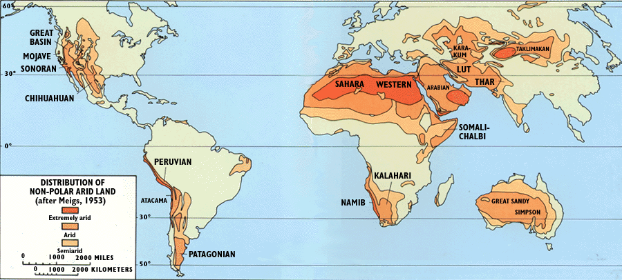
The cold desert climate is found in the rain shadow areas of temperate zones. These deserts are usually found on higher altitudes than hot deserts. Some ideal examples of this climate are Patagonian Desert (Argentina), Gobi desert (Mongolia), Kyzyl Kum, Taklamakan and Katpana (Central Asia), Leh and Ladakh (Great Himalayas). World distribution of hot and cold deserts (Arid climates) is given in Figure 5.
Figure 5: World Distribution of Arid Climates

Source: https://pubs.usgs.gov/gip/deserts/what/world.gif
Temperature
The sub divisions of the arid climate as per the Koeppen climate classifications (BWh and BWk) are already discussed earlier. To delineate hot desert climate from cold desert climates, the isotherm of 180 C mean annual temperature is most commonly used. The places above this temperature are classified as hot arid (BWh) and below as cold arid (BWk).
Annual distribution of temperature in the dry climate regions of the world has two distinct seasons, summer and winter. Average distribution of temperature during summer ranges from 300 C to 350 C but mid-day temperature exceeds 400 C. On 13th September 2012, the Guinness Book of World Records modified the highest recorded temperature of El Azizia, Libya (580C) to now Greenland Ranch (56.70C), Death Valley, Caifornia, USA. Temperature in cold deserts remain warm in summer but extremely cold during winter. The average temperature in this climate remain less than 100C. Annual and diurnal both the temperature ranges remain quite high in the desert climates.
Pressure and Winds
Hot deserts are found in the areas of anticyclonic conditions of subtropical high. Descending air from above causes high pressure. It leads to compressing of the air and warming as well. Increasing temperature of the air increases the capacity of the air to hold moisture. Therefore, instead of leaving moisture, air extracts moisture from the area/waterbody/soil. These conditions are the cause for the happening of desert in the subtropical areas.
On the western coast of the continent, cold currents are prevailing. They themselves are cold and the winds reaching the coast are cool. They do not have sufficient amount of moisture for raining. Another point with regard to this cool winds is that when they reach the western coastal land parts, the winds get warmed up due to more temperature. That is the reason that the rainfall in not there and hence, deserts are existing.
Rainfall
The annual precipitation in the desert regions of the world is (on an average) less than 20 cm. Some deserts like Sahara get even less than 10 cm (Cairo of Egypt 3 cm). Some other places of this climate also receive average annual rain less than 10 cm such as Lima of Peru 5 cm, Yuma of Arizana (USA) 8 cm, Tolo in South West Africa 5 to 6 cm, Berbera in Somalia 1cm, Lovelock Nevada 1.5cm (Figure 6). Southern part of Chile is very erratic in rainfall. The desert regions, sometimes experience heavy down pore by occasional storms which cause flash floods. Such floods bring massive destruction, since there is no regular outlet of water and the quick rain becomes the reason to spread over a large areas. Cold deserts have rainfall usually in the form of snow and some rain here is received around spring.
Skies in arid climates, specifically in tropical desert climate region, are generally free from clouds allowing the sun’s rays reach the ground. The cloudiness here remain between 1/10 to 1/30 cloud cast of the sky. This keeps the ground baked under the sun. Sometimes formation of clouds cumulo-nimbus clouds is seen here. Thunder and lightning is experienced but without any rain as raindrops are evaporated before reaching the ground surface.
Figure 6: Temperature and Precipitation at Berbera and Lovelock
Berbera, Somalia (BWh) Lovelock, Nevada, USA (BWk)

Natural Vegetation
Most of the plant species of the desert have found remarkable ways to survive. Desert succulents (cacti or rock plant) survive by accumulating moisture in their fleshy tissues. An extensive system of shallow roots help them to capture soil water. These hot desert plants are leafless, vertically erect and columnar in growth. These xerophytic plants have properties of cuticularization (surface plaster like layer of cutin), cutinazation (formation of water tight layer with abundant hair), and special formation of stomata in recesses and grooves in order to protect the plant from harsh arid environment (Figure 7).
Figure 7: Vegetation of Arid Climate
Hot Desert Vegetation Cold Desert Vegetation

Source: http://sciencing.com/do-plants-animals-adapt-desert-6516007.html and https://www.desertusa.com/life.html
Vegetation in cold deserts generally include grasses, shad scale and camel’s thorn. Some places where no vegetation growth is possible, lichens are found. Some plants, in this climate, are found with much wider gap. It is probably to get the sufficient subsurface water through the roots for their survival. They are basically bushes and their height is between 15 cm to 122 cm. These plants are deciduous and have spiny leaves (Figure 7).
Animal Community
Camels, foxes, jackals, snakes (sidewinders), scorpions etc. are the animals who have adapted the conditions of hot desert climate (Figure 8). Camel can store water in its bloodstream and can drink up to 40 gallons water in 10 minutes. It can survive many days without water. Other animals have also found their ways to survive in extreme hot weather. These animals are called xerocoles.
Figure 8: Some Animals of Hot Desert

Source: https://sites.google.com/site/climatetypes/arid
Some animals have adapted the climatic conditions of cold desert like dear (in winter with thick fur coat), gazelles, jack rabbits, gerbils, saiga antelope, wolfs, desert tortoise, lizards, kangaroo rat, pocket mice, grasshopper mice, etc. These animals usually hide themselves in burrows and in similar places in extreme weather conditions.
Reptiles are cold blooded (ectotherms) so they are unable to live in cold deserts and are well suited for hot deserts. Lizards and snakes are found in abundance in hot deserts. Some snakes have developed unique method of locomotion. They move sideward (horned viper and sidewinder) and can easily navigate high sand dunes (Figure 9) .
Human Activities
People have been living in deserts since millennia. Tribes like Bushman in Kalahari, Aborigines in Australia were originally hunter-gatherers. Later on they developed many skills such as animal tracking, finding water in deserts, manufacturing and use of weapons etc. In other cultures people are herders and have developed nomadic way of life. They move to new pastures with their goods, baggage and animals (sheep, goats, cattle, yak, llamas and reindeer). These nomads are traders and they are still dealing with ivory or gold items etc. This traditional means of overland transport have declined now but caravans still travel along the ancient routes carrying salt from interior to desert edge communities.
Apart from trade, other activities are natural resource extraction, farming, solar energy capture, wind energy generation and warfare etc are also developed mainly in the hot deserts. Many minerals such as gypsum, sodium nitrate, sodium chloride, borates, copper, iron, uranium along with salts, pumice, fossil oil and gas are extracted from the deserts around the world.
Farming has been an age old practice in some areas (Judean 600 BC, south western USA, 600 AD, of deserts. Today also agricultural activity is done through irrigation and crops like millets, beans, squash, pepper and sugarcane are grown here.
Summary and Conclusions
In a nut shell, major determinant of the ‘dry climates’, is the amount of rainfall which influences the vegetation and ultimately the animal and human life. The common characteristics of these climates are low precipitation, high evaporation rate and wide range of daily and annual temperature. These climates (arid and semi arid) cover nearly 26 percent of the earth’s land area of which 12 percent is under arid climates. Grass lands of semi arid climates are cultivated in a very organized manner and the resources of arid climates are also extracted vigorously. Problems of ecological imbalances are noticed in these climates. Several efforts have been initiated to tackle these problems but a judicious way of human activities are the sole solution in this regard.
| you can view video on DRY CLIMATES: SEMI ARID AND ARID |
References
- Barry, R.G. and R.J. Chorley (2016) Atmosphere, Weather and Climate, Routledge: New York.
- Chandrasekar, A. (2010): Basics of Atmospheric Science; PHI Learning Private Limited.
- Critchfield, H.J. (2011) General Climatology, Phi Publication.
- Fredrick, K.L and Edward J.T: Atmosphere; Prentice-hall of India PVT, New Delhi.
- Lal, D.S: Climatology, C.S Jian for Chaitanya Publishing.
- Lydolf, P.E. (1985): The Climate of the Earth, Rowman.
- Miller, A. and R.A. Anthes (1980) Meteorology, Columbus Publication: Ohio.
- Robinson, P.L. and Henderson, S. (1999): Cotemporary Climatology, Henlow.
- Siddhartha, K. (2014) Atmosphere, Weather and Climate; A text book on Climate; Kisalaya PublicationPvt. Ltd.
- Singh Savendra: (2016) Climatology, Pravalika Publications: Allahabad.
- Strahler, A.N. (1965) Introduction to Physical Geography, Willey: New York.
Web Links
- http://bomaproject.org/
- http://sciencing.com/characteristics-arid-climates-8441465.html
- http://sciencing.com/semiarid-climate-10009421.html
- http://www.differencebetween.info/difference-between-weather-and-climate?gclid=EAIaIQobChMI8fq4nNCD1gIV0xFoCh2xWQRiEAMYASAA
- http://www.fao.org/docrep/t0122e/t0122e03.htm
- http://www.fao.org/docrep/t0122e/t0122e03.htm
- http://www.guinnessworldrecords.com/world-records/highest-recorded-temperature
- http://www.history.com/news/the-hottest-day-on-earth-100-years-ago
- http://www.meteorologyclimate.com/Semiarid-climate.htm
- http://www.scienceforums.com/forum/34-earth-and-climate-science
- https://courses.lumenlearning.com/geophysical/chapter/dry-climates-group-b..
- https://link.springer.com/referenceworkentry/10.1007%2F1-4020-3266-8_16
- https://link.springer.com/referenceworkentry/10.1007%2F1-4020-4494-1_300
- https://sites.google.com/site/climatetypes/semiarid
- https://www.britannica.com/science/veld
- https://www.idrc.ca/sites/default/files/sp/Documents%20EN/CARIAA_COP18_Policy_Semi -arid.pdf
- https://www.mapsofworld.com/referrals/weather/climate/dry-climate.html