16 ATMOSPHERIC MOISTURE II, CONDENSATION, PROCESSES AND FORMS
Dr. Jitender Saroha

Objectives
- define condensation and sublimation;
- point out pre-conditions of condensation process;
- explain the adiabatic and non adiabatic processes
- associated with condensation;
- describe and differentiate all forms of
- condensation like dew, frost, fog and clouds; and
- explain types of fog and clouds.
Contents
Introduction
Learning Objectives
Concept ofCondensation
Processes of Condensation
Adiabatic Processes
Orographic Lifting
Frontal Wedging
Convergence
Convective Lifting
Cooling by lowering of barometric pressure
Nonadiabatic Processes
Forms of Condensation
Dew
Frost
Fogs: Radiation; Advection; Upslope; Evaporation and Frontal
Clouds
High Clouds
Middle Clouds
Low Clouds
Summary and conclusions
Multiple Choice Questions
Answers:
References
Web Links
Introduction
You must have noticed that when we place a cold water bottle from refrigerator on table, after sometime water droplets emerge on its surface. This is because of the process of condensation. Condensation is the process of the change of state from water vapour to the liquid water. When moist air is cooled below its dew point or condensation temperature, some of the air’s water vapour becomes liquid. Any further cooling of that saturated air initiates the process of condensation. During this process,the latent heat of condensation is released, which was consumed at the time of evaporation. It works as the main source of heat energy for atmospheric processes. In this module, focus is on processes of condensation and forms of condensation, including sublimation.
Concept of Condensation
The process of change of state from water vapour to water is known as condensation. It takes place due to cooling of moist air upto dew point. It is the temperature at which saturation takes place and water vapour starts changing into water droplets. In case, the dew point is achieved below freezing point, water vapour is directly converted into ice, this process is known as sublimation. It is also called crystallization or deposition by some scholars. Latent heat of condensation and sublimation is released during these phase changes of water. This heat plays vital role in atmospheric processes.
In cooling free air, condensation and sublimation require the presence of condensation and sublimation nuclei. They must be present in large number and must be hygroscopic, that is having an affinity for water vapour molecules. Salt from oceanic sources is strongly hygroscopic. Other condensation nuclei are dust particles and smoke, in specific size ranges. Condensation may take place upon most active hygroscopic nuclei even at temperatures above dew point, that is, when the relative humidity is less than 100 per cent. It is noteworthy that in the absence of condensation nuclei, a relative humidity well above 100 per cent is required for condensation.
Normally, condensation begins at dew point but at some occasions it starts only after cooling of air much below its dew point and it represents situation of supersaturated.We are familiar with the fact that liquid water changes to ice when temperature falls to the freezing point, 00C or below. However, clouds consist entirely of water droplets at temperatures below at about -120C. In fact, pure water suspended in air does not freeze until it approaches a temperature of about – 400C.The water droplets in this situation are referred as supercooled.The supercooled water droplets will readily freeze if it strikes an object such as hygroscopic nuclei or surface. The forms of condensation on surface are dew and frost, in air in contact with surface, fog and well above surface, clouds.
Condensation depends upon amount of cooling and relative humidity of the air. These two factors depend on temperature, evaporation, pressure and volume of the air. Therefore, condensation takes place under the following four situations:
(i) the volume of moist air remains constant but temperature falls below dew point;
(ii) the volume of the moist air increases without any addition or subtraction of heat;
(iii) the combined change in volume and temperature reduces the moisture-holding capacity of air; and
(iv) finally, when evaporation results into additional supply of moisture.
Basically, condensation is produced by processes of cooling of moist air.
Processes of Condensation
Some kind of cooling process is generally required to initiate and sustain condensation or sublimation. In general, the cooling is associated with four different processes:
(i) cooling by expansion,
(ii) cooling by conduction of heat from the air,
(iii) cooling by radiation from the air and
(iv) cooling by mixing of warm and moist air with cold air.
These cooling processes are classified into two broad categories – adiabatic and nonadiabatic or diabatic processes. The first represents cooling by expansion and nonadiabatic class includes the rest three processes of cooling. The following section briefly describes these processes of condensation.
The cooling processes are as follows:
1. Adiabatic processes:
a. Rising and expanding air, resulting into clouds, because of
(i) Convection
(ii) Convergence of winds
(iii) Convergence of air masses
(iv) Orographic lifting
b. A decrease in barometric pressure at surface, may result into fog
2. Nonadiabatic or Diabatic processes
a. Cooling due to loss of heat by radiation. Direct radiation from moist air may result into fog or clouds.
b. Contact cooling with cold surface (conduction). Dew, frost, or fog may form.
c. Contact cooling associated with the movement of air across a cold surface (advection).
d. Mixing of warm air with colder air. It depends on sufficient moisture and cooling upto dew point. Fog and clouds will develop on hygroscopic nuclei.
Adiabatic Processes
Of all the types of cooling listed above, the most significant for condensation in free air is cooling due to rising air. The rising air experiences a drop in temperature,because internal energy is used in expansion caused by declining environmental pressure with altitude. As the individual molecules of gas are more widely diffused, they do not move so fast, the sensible temperature of the expanding gas declines. Conversely, descending air experiences an increase in pressure and temperature. These temperature changes without any heat exchange with surrounding, means without any heat being added or subtracted from the air are called adiabatic (Figure 1).
Figure 1: Adiabatic (Dry Air) Cooling and Warming

Source:http://www.geography.hunter.cuny.edu/tbw/wc.notes/4.moisture.atm.stability/dalr.graphic.jpg
Within the rising parcel of air the rate of fall of temperature is known as the dry adiabatic lapse rate and as shown in Figure 1, it is 100C per km of vertical uplift.This rate is effective till there is no condensation. The dew point also decreases gradually with air moving upward; the rate is 1.80C per km (Figure 2).
Figure 2: Adiabatic Change in Temperature in a Rising Parcel of Air

Source: https://i0.wp.com/www.nandyradiotelephony.com/wpcontent/uploads/2015/09/CloudFormation.gif
Let us assume that a parcel of air near the earth surface has a temperature of 200C and that here its dew point temperature is 11.80C, as shown in Figure 2. If this parcel of air starts rising gradually, its air temperature decreases much faster (as rate is 100C/km) than its dew-point temperature (as rate is 1.80C/km). At one km altitude, the temperature of rising parcel of air due to adiabatic change becomes 100C and it achieves dew point temperature and gets saturated. Further rise results in condensation of water vapour into minute water droplets, and thus cloud formation takes place. In case, this dew point is below freezing point or air is supercooled, the ice crystals will develop on sublimation nuclei. The end result of whole process is the formation of clouds.
The level of condensation is generally visible in the form of flat base of clouds. Condensation goes on in this rising parcel of air and due to release in latent heat of condensation, the adiabatic rate is substantially reduced.The new rate of cooling is known as the wet adiabatic rate; it is basically, the dry adiabatic lapse rate (DALR) modified by the release of latent heat of condensation. The wet adiabatic value varies between 30 and 60C per km, with temperature and pressure (and therefore with altitude attained by ascending air), averaging about 60C per km.wet adiabatic rate is also known as saturated adiabatic lapse rate (SALR).
Adiabatic cooling due to lifting is accomplished by any of the following four ways or by any combination of them.
Orographic Lifting: It is ascension of air caused or intensified by any elevated terrain, such as mountains, hills and plateau acting as a barrier. Even a slight rise in terrain height, for instance on a coastal plain, can induce some rise of air. Even in this plain area the frictional drag of to pography is more than that of the ocean surface. This frictional drag reduces the velocity of winds and air coming from sea is forced to rise over this congested air barrier in order to move towards continental interiors. In case of bigger barriers the lifting process is more intense. The rising air, through adiabatic cooling, often produces clouds and precipitation. On the leeward side the descending air adiabatically becomes warmer and dry and normally creates rain shadow zone (Figure 3)
Figure 3: Orographic Lifting and Adiabatic Cooling

Source:http://web.gccaz.edu/~lnewman/gph111/topic_units/Labs_all/orographic_uplift_picture.gif
Frontal wedging: The convergence of warm and cold air masses results into formation of fronts. This weather phenomenon is very common in mid-latitudes. In frontal zone, the cooler and denser air works as barrier and over which warmer and less dense air rises. This process is known as frontal wedgingor frontal lifting. The collision of contrasting air masses forces results in condensation in fronts and associated temperate cyclones (Figure 4).
Figure 4: Frontal Wedging

Source:http://www.geography.hunter.cuny.edu/tbw/wc.notes/4.moisture.atm.stability/frontal.wedging.jpg
Convergence: Frontal lifting is specifically related to convergence of air masses. In general, convergence takes place when winds of different directions or speeds meet one another. In the tropical areas, the converging winds have normally similar characteristics. For instance, converging winds at Florida peninsula from the Atlantic side as well as the Gulf of Mexico. Most important, convergence as a mechanism of forceful lifting is a major contributor to the weather conditions associated with tropical cyclones (Figure 5).
Figure 5: Convergence and Convective Lifting

Source:http://images.slideplayer.com/24/7016615/slides/slide_16.jpg
Localized Convective Lifting: Convection as process resulting to adiabatic cooling is normal whenever the earth’s surface is warmer than the air above. In summer season, on warm days the differential rates of heating of surface results into formation of parcels of air warmer than surrounding air (Figure 5). This process results into localized convective lifting. This warm and moist air may rise upto level of condensation and result into clouds and light rain. This type of convection mechanism also contributes significantly to the lifting initiated by the other mechanisms. It should be noted that while the other mechanisms force air to rise, convective lifting occurs automatically because air is warmer and less dense than adjoining air.
Cooling by Lowering of Barometric Pressure
Adiabatic cooling occasionally can result into condensation due to lowering of barometric pressure in a moist air at the ground level, which occurs because of change of general distribution of pressure over that area. The valleys or basins filled with stagnant moist air are the most probable and ideal sites for these conditions as less dense air moves overhead. This may result into the formation of extremely rare barometric fog. This cooling process also intensifies other types of fog.
Nonadiabatic or Diabatic Processes
These processes involve exchange of heat with an external source. In nonadiabatic processes the dew point can be achieved through the processes such as – cooling due to loss of heat by radiation, contact cooling with cold surface (conduction) contact cooling associated with the movement of air across a cold surface (advection) and due to mixing of warm air with colder air. Condensation in these processes depends on sufficient moisture, cooling up to dew point and for fog and cloud formation condensation nuclei.
Forms of Condensation
Condensation takes place on solid surfaces on the earth’s surface as well as in free air near and away from it. The common forms of condensed moisture on surface are – dew and frost, adjacent to the surface in air – fog and at greater heights – clouds. A brief description of these is provided in the following sections.
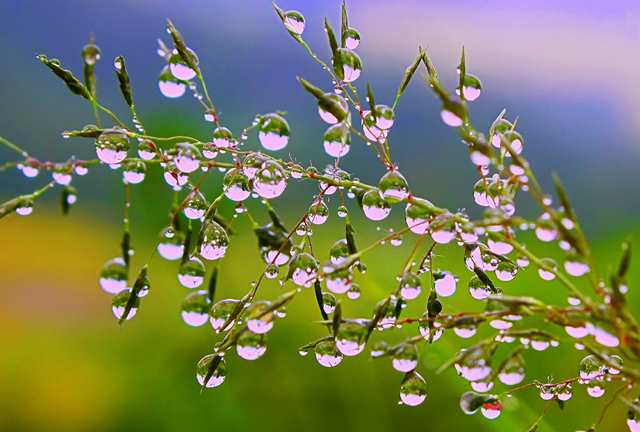
Dew
During night time surface cooling occurs due to radiation from earth surface (Figure 6). Occasionally, the cooling is so intense that the temperature of the moist air touching the surface falls below dew point. It results into dew formation or water droplets formation on features such as – stones, blades of grass and leaves of plants.The favourable conditions required for this nonadiabatic cooling of surface by radiation are following – long nights, clear sky, calm and moist air.
Figure 6: Dew – Form of Condensation

Source:http://www.incrediblesnaps.com/wp-content/uploads/2011/12/55-stunning-dew-drop-photographs-13.jpg
Frost
Normally, frost is mistaken as frozen dew. Frost occurs when the dew point of air drops below the freezing point. It means white frost is result of sublimation or crystallization or deposition that is direct transformation from water vapour to ice crystal (Figure 7). The favourable conditions for frost formation are the same as for dew only addition is that dew point is below freezing point.
Figure 7: Frost – Form of Condensation

Fog
Fog represents microscopic water droplets suspended in air with base at or near surface. It reduces horizontal visibility to less than one km. Fog has great similarity with clouds only difference is of location and process of formation. Fogs are mainly formed near surface by nonadiabatic cooling like radiation, conduction and mixing of airs and air masses. Clouds are result of adiabatic cooling caused by lifting processes. Generally, following types of fogs are predominant.
Radiation Fog: During night time surface cooling takes place due to loss of heat by terrestrial radiation. This cooling results into dew point temperature in adjacent moist air. Light winds, clear sky and moist air are the favourable conditions required for radiation fog (Figure 8). Radiation fog occurs on lands instead of seas, and especially in interior lands and valleys. It has a distinct diurnal periodicity, present during night and early morning and starts disappearing after the sunrise. It is also known as ground fog.Basically, it develops due to inversion of temperature formed by radiation cooling. The thickness of ground fog is in the range of 1 to 300 m. It is most common during autumn and winter seasons.
Figure 8: Radiation Fog

Source: http://mrcc.isws.illinois.edu/living_wx/fog/radiationfog.png
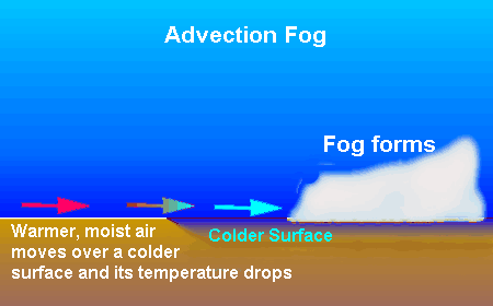
Advection Fog: Advection fog develops due to the horizontal movement of moist and warm air over a cold surface. It becomes chilled due to contact cooling and achieves dew point and forming a blanket of fog (Figure 9). The ideal locations for their occurrence are sea coasts, large inland water bodies like the Great Lakes of North America and the convergence areas of warm and cold ocean currents. These are most frequent over oceans and large inland bodies of water during summer season and over lands in winter season.
Figure 9: Advection Fog

Upslope Fog: Upslope fog is produced due to cooling by adiabatic expansion of upslope rising air. It is also called hill fog or orographic fog (Figure 10). However, in North America it is common in the Great Plains. Here, warm and moist air from the Gulf of Mexico moves towards Rocky Mountains. In its journey, it gradually rises with topography and expands adiabatically and results into an extensive fog cover over the western plains (Figure 11). Upslope fog is also common on eastern slope of the Great Dividing Range of Australia because of uplift of maritime air.
Figure 10: Upslope Fog

Figure 11: Various Types of Fogs in USA

Source:http://www.earthonlinemedia.com/ebooks/tpe_3e/atmospheric_moisture/fog_USA.jpg
Evaporation Fog: Evaporation fog occurs when a cold air mass moves over a warm water surface. As the cold air comes in contact with warm water, evaporation takes place due to heating. After saturation, condensation occurs in the form of steam fog in cold air. In Arctic and Antarctic areas, it appears as ‘sea smoke’ when very cold air moves over the warm waters along the edge of ice. Evaporation fogs are also known as ‘steam fogs’ (Figure 12). Usually, evaporation fog is very shallow.
Figure 12: Evaporation Fog or Steam Fog

Source: http://slideplayer.com/slide/7016586/24/images/33/Steam+Fog.jpg
Frontal Fog: Fogs formed along the front of two different types of air masses are known as frontal fogs. Warm and moist air rises on frontal slope and due to contact and adiabatic cooling gets condensed as fog. Frontal fogs are identified as pre-frontal fog, post-frontal fog and precipitation fog.
In case, the uprising air velocity is relatively high, the base of condensation layer will move above surface to form a low stratus cloud. In case, these clouds yield rain, and the cold air below is close to the dew point, sufficient rain can evaporate to form fog. This type of fog is known as precipitation fog (Figure 13). The end result may be a more or less continuous extent of fog from surface to cloud.
Figure 13: Frontal Fog

Clouds
Clouds represent a visible aggregate of minute droplets of water, or tiny ice crystals or a mixture of both. Clouds are usually product of condensation or sublimation caused by lifting process or adiabatic cooling, as discussed earlier. Clouds play a vital role in heat budget and cause precipitation. They are very useful indicators of various weather phenomena and flying conditions. Clouds are classified mainly on the basis of two criteria – form and height. The three basic forms are:
cirrus (fibrous or feathery appearance or like silky filament), cumulus (globular shape or cauliflower like structure) and stratus (as sheets or layers).
Generally, clouds have one of these forms or combinations of them.
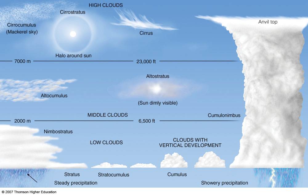
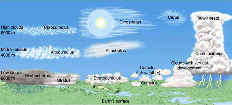
The International Cloud Atlas WMO (World Meteorological Organisation, 1956) has classified the infinite variety of clouds into ten main types of genera on the basis of height (Figure 14). High clouds (base above 6 km), middle clouds (2-6 km) and low clouds (base below 2 km). These altitudinal ranges are not fixed, rather they vary somewhat by season and latitude. Towards pole the height of high clouds generally occur at lower altitudes. In addition, there are vertical clouds which extend in all height ranges.A brief description of these ten types is provided in the following sections.
Figure 14: Types of Clouds

Source: https://www.metabunk.org/data/MetaMirrorCache/77f62d71d61bcb2a27b9957cfcbfdf7d.jpg
High Clouds
The high clouds are usually found in the altitude zone of 6 to 12 km from the earth surface.Three cloud types, namely cirrus, cirrocumulus and cirrostratus constitute the family of high clouds. All these clouds are composed of mainly ice crystals because at greater heights amount of moisture is less and dew point is achieved at low temperatures in supersaturated situation. They appear white. These high clouds are generally associated with fair weather conditions, but occasionally warn of impending stormy weather.
Cirrus: These are detached clouds composed of white, delicate, ice filaments. These clouds have a fibrous appearance like ‘mares tails’ or a silky sheen or both. Generally, detached and irregular arrangement of these clouds indicates fair weather conditions. But occasionally, when arranged systematically in bands or connected with cirrostratus and altostratus, they indicate weather disturbance like a storm.
Cirrostratus: These clouds represent a thin, milky or whitish sheet of fibrous appearance covering the sky totally or partially.They are composed of tiny ice crystals. They are easily recognized when they produce halo around moon or sun (Figure14). The halo is produced by refraction of light by ice crystal suspended in air. They usually indicate about approaching storm.
Cirrocumulus: These clouds are patches of small white flakes or small globules which are arranged in ripples or wavelike form. Wavelike regular pattern forms a ‘mackerel sky’. These clouds are least common in high clouds.
Middle Clouds
The middle clouds are in the altitudinal range of 2 to 6 km and have prefix alto in their names. The two types are – altocumulus and altostratus. They are composed of water droplets, ice crystals or both. The occasional optical effect associated with these middle clouds is not halo rather corona i.e. a small circle of light around moon or sun. It is produced from the diffraction of light by water droplets and its diameter is inversely proportional to water droplets size in clouds.
Altocumulus: These clouds consist of layer or patches of white or grey globular clouds, generally arranged in fairly regular pattern of lines, groups or waves. They are generally composed of supercooled water droplets. Altocumulus clouds differ from cirrocumulus as cirrocumulus clouds are smaller and less dense. They differ from stratocumulus because stratocumulus clouds are larger and have shadows. The high globular group within altocumulus clouds is known as sheep clouds or wool pack clouds.
Altostratus: Altostratus clouds appear as fibrous sheet of gray or blue-grey, covering the sky totally or partially. They are thicker than the higher cirrostratus. They do not exhibit halo phenomena. They are usually associated with warm fronts. These clouds are associated with infrequent precipitation either in the form of light snow or drizzle.
Low Clouds
Stratus, stratocumulus, nimbostratus cumulus and cumulonimbus clouds come under the category of low clouds. Cumulus and cumulonimbus clouds have their base in the range of low clouds, but they extend upward into the middle or higher altitude. On the basis of height of their base they come under the category of low clouds, but some scholars classify them in a separate category, as clouds of vertical development also.
Stratus: Stratus clouds generally represent grey coloured uniform layer covering much of the sky. They are composed of many uniform layers. These are dense and low-lying fog-like clouds. The uniform of these clouds indicate a temperature inversion.
Stratocumulus: These are large globular masses or rolls of grey or whitish or both. These globular masses are usually arranged in lines, groups or waves. They are usually associated with fair weather but occasional rain and snow may occur.
Nimbostratus: The Latin word nimbus means ‘rain cloud’ and stratus stands for layered. Therefore, these are rainy clouds. These clouds bring light to moderate rainfall for long durations over widespread areas. These are thick very low clouds which bring complete darkness and precipitation. The rain, snow and sleet are associated with these clouds but are never accompanied by thunder, lightning or hail.
Cumulus: These clouds are dense, widespread, dome-shaped (resembling a cauliflower) and have flat bases. These clouds predominantly represent the top of the effective convective currents. The vertical extent depends on the power of vertical currents and amount of release of latent heat of condensation. If both are intense they may grow to emerge as cumulonimbus clouds. The cumulus clouds of limited vertical extent usually represent fair weather. Convergence of a large group of cumulus clouds becomes stratocumulus and inversely breaking apart of stratocumulus forms cumulus.
Cumulonimbus: These clouds show great vertical extent, from a few hundred meters above the ground upward to 14 to 18 km. They have a flat base and flat spreading out top as an ‘anvil head’ of cirrus. These are dark and dense thunderstorm clouds associated with heavy rain, snow and hail (occasionally) usually accompanied by lightning, thunder and gusty winds. These clouds are common in equatorial low pressure belts and in tropical cyclones.
Global Cloud Cover
On an average at any time, clouds contain only about 4 per cent of the total water in the atmosphere. Although this share is small but they play a vital role in hydrological cycle. Clouds represent an important sink for radiative energy by absorption, reflection and reradiation of energy in the earth-atmosphere system. They are actual and potential source of precipitation. The distribution of cloud cover shows characteristic geographical, latitudinal and seasonal variations. Cloudiness represents the extent of total area of the sky covered by clouds. It is generally expressed in percentage.
The zonal distribution of clouds is similar to distribution of precipitation pattern, with one exception. The equatorial low pressure belts are associated with heavy convectional precipitation but the cloud cover extend is reported low at about 53 per cent on an average. This because of dominance of vertical cumulus and cumulonimbus clouds which do not have large horizontal extents. The maximum cloudiness prevails in middle and higher latitudes, especially in southern hemisphere over the oceans. In the latitudinal zone 600-700 S, three-fourth of the sky is cloud covered. The lowest cloud cover extent is in 200-300 N latitudinal zone. Here, it is, on an average, only 45 per cent and over continents in this belt in northern hemisphere, it is about 34 per cent. Therefore, minimum cloud cover is associated with the subtropical high pressure belts. The prime maxima of clouds in middle and high latitudes are associated with fronts and cyclones. These have dominantly stratus type of clouds which extend over large areas but result into light or moderate precipitation.
The zonal spatial distribution of cloud cover changes with seasons with varying intensities. During summer of northern hemisphere, due to monsoon onset and shifting of pressure belts, high cloudiness is observed over southeast Asia, West Africa, northwestern South America and low cloudiness over the southern hemisphere landmasses, southern Europe, North Africa and the Near East. In the northern winter, the tropical areas of southern hemisphere experience high cloudiness. The maximum cloud cover irrespective of seasons prevails over the open oceans belt at 500-700 S and over large parts of northern hemispheric oceans north of 450 N, with a range of 66-76 per cent. Diurnal variations of cloudiness mainly depend of types of clouds. For instance, stratus and other stratiform clouds reach their maximum in the early morning whereas the cumulus and cumulonimbus around afternoon.
Summary and Conclusions
Condensation is the process of the change of state from water vapour to water. When moist air is cooled below its dew point or condensation temperature, some of the air’s water vapour becomes liquid. Any further cooling of that saturated air initiates the process of condensation. In case, the dew point is achieved below freezing point, water vapour is directly converted into ice by the process of sublimation. Latent heat of condensation and sublimation is released during these phase changes of water.
The condensation processes are classified into two broad categories – adiabatic and nonadiabatic processes. The adiabatic process involves cooling due to expansion and it is associated with – rising and expanding air due to convection, convergence of air, and orographic lifting. The nonadiabatic processes involve cooling due to radiation, conduction, advection and mixing of warm and cold air.
Condensation takes place on solid surfaces on the earth’s surface as well as in free air near and away from it. The common forms of condensed moisture on surface are – dew and frost, adjacent to the surface in air – fog and at greater heights – clouds. Dew occurs due to contact cooling of moist air below dew point and frost when dew point is below freezing point. Fog represents microscopic water droplets suspended in air with base at or near surface. It reduces horizontal visibility to less than one km. The major types of fogs are – radiation fog, advection fog, upslope fog, evaporation fog and frontal fog.
Clouds represent a visible aggregate of minute droplets of water, or tiny ice crystals or a mixture of both. Clouds are product of condensation or sublimation usually caused by lifting process or adiabatic cooling. The ten main types of clouds are – cirrus, cirrostratus, cirrocumulus, altocumulus, altostratus, stratus, stratocumulus, nimbostratus, cumulus and cumulonimbus. The distribution of cloud cover shows characteristic geographical, latitudinal and seasonal variations. The maximum cloudiness prevails in middle and higher latitudes, especially in southern hemisphere over the oceans. In the latitudinal zone 600-700 S, three-fourth of the sky is cloud covered. The lowest cloud cover extent is in 200-300 N latitudinal zone of subtropical high pressure belts and associated deserts.
| you can view video on ATMOSPHERIC MOISTURE II, CONDENSATION, PROCESSES AND FORMS |
References
- Barry, R.G. and Chorley, R.J. (1998) Atmosphere, Weather and Climate, Routledge, London.
- Critchfield, H.J. (1983) General Climatology, PHI Learning Private Limited, New Delhi.
- Frederick, K.L and Edward, J.T. (2010) The Atmosphere – An Introduction to Meteorology, PHI Learning Private Limited, New Delhi.
- Khullar, D.R. (2012) Physical Geography, Kalyani Publishers, New Delhi.
- Lal, D.S. (1993) Climatology, Chaitanya Publishing House, Allahabad.
- Lal, D.S. (2009) Physical Geography, Sharda PustakBhawan, Allahabad.
- Oliver, J.E and Hidore, J.J. (2003) Climatology: An Atmospheric Science, Pearson Education, Delhi.
- Singh, S. (2015) Physical Geography, Pravalika Publications, Allahabad.
- Strahler, A.N. and Strahler, A.N. (2001) Modern Physical Geography, John Wiley and Sons, Singapore.
- Trewartha, G.T. and Horne, L.H.(1968) An Introduction to Climate, McGraw-Hill, New York.
Web Links
- http://addins.wrex.com/blogs/weather/wp-content/uploads/2010/07/slopefog.jpg
- http://www.earthonlinemedia.com/ebooks/tpe_3e/atmospheric_moisture/fog_USA.jpg
- http://slideplayer.com/slide/7016586/24/images/33/Steam+Fog.jpg
- http://astronomyonline.org/SolarSystem/Images/Earth_Moon/CloudTypes.jpg
- http://i.dailymail.co.uk/i/pix/2012/01/16/article-2087332-0F7D56A800000578-448_964x640.jpg
- http://images.slideplayer.com/24/7016615/slides/slide_16.jpg
- http://mrcc.isws.illinois.edu/living_wx/fog/radiationfog.pn
- http://slideplayer.com/slide/3925846/13/images/32/FRONTAL+FOG+SATURATION+OF+COLD+AIR+BY.jpg
- http://www.geography.hunter.cuny.edu/tbw/wc.notes/4.moisture.atm.stability/dalr.graphic.jpg
- http://www.geography.hunter.cuny.edu/tbw/wc.notes/4.moisture.atm.stability/frontal.wedging.jpg
- http://www.incrediblesnaps.com/wp-content/uploads/2011/12/55-stunning-dew-drop-photographs-13.jpg
- https://1.bp.blogspot.com/-mgiDZmYWZ3g/TqecJ-134VI/AAAAAAAAAkM/sj2l-Ycut5w/s1600/AdvectionFog.gif
- https://i0.wp.com/www.nandyradiotelephony.com/wpcontent/uploads/2015/09/CloudFormation.gi f
- http://web.gccaz.edu/~lnewman/gph111/topic_units/Labs_all/orographic_uplift_picture.gif
- https://media1.britannica.com/eb-media/11/611-004-9056394D.jp
- https://www.metabunk.org/data/MetaMirrorCache/77f62d71d61bcb2a27b9957cfcbfdf7d.jpg