14 OCEAN- ATMOSPHERE INTERACTION
Dr. Kanchan Singh

Introduction
LearningObjectives:
Forces Responsible for Ocean – Atmosphere Interaction
Processes and Factors Responsible for Ocean-Atmosphere Interaction Medium of Interaction:
Air:
Winds:
Salt Aerosols:
Feedback mechanisms:
Walker Circulation
Atmospheric cells in Ocean-Atmosphere Interaction Hadley Cell:
Ferrel Cell: Polar Cell:
Jet Streams in Ocean Atmospheric Interaction
Polar jet:
Subtropical jet: Easterly jet:
Rossby Waves:
Ocean Waves and Currents:
Land and Sea Breezes:
El Nino Phases:
El Nino and Monsoon:
La Nina and Monsoon:
Southern Oscillations Phases
Positive Southern Oscillation:
Negative Southern Oscillation:
Seasonal Cycle
Conclusions
References
Web Links
Multiple Choice Questions
Answer Keys
Introduction
The major driving force of ocean – atmosphere interaction is solar heating. It is greatest near equator and keeps on declining towards poles. Ocean – atmospheric circulation transports energy from higher received region to lower. The resultant is the declining temperature gradient from equator to poles. Ocean and atmosphere are in constant exchange of heat, water and momentum. The interaction of the ocean and atmosphere adds rhythms in the structure of the worldclimates. This is the result of buoyancy of warm air rising from the equator to troposphere. As it is pushed upwards by air rising from below, cooling begins at high altitude. The sinking of air near subtropics and equator ward return near the surface completes the cycle. The oceanic interaction transports moisture in the atmosphere in the form of water vapor. Cold currents originating in the poles flow towards equator while warm currents originating in equator flow towards poles. Thus, currents play a vital role in transporting heat and moisture. Condensation of water vapor results in the cloud formation that takes place in the atmosphere. Precipitation and its distribution over the world is the result of ocean atmosphere interaction. Meteorologists have developed models to explain the complex interaction.
Solar radiation is the ultimate driving force for all motions in the ocean and atmosphere and gives rise to the pronounced and regular diurnal and seasonal cycles throughout the world. Climate not only displays repeating and regular cycles of solar radiation, but also displays variability that is not correlated with solar radiation.An attempt has been made to study the ocean and atmosphere interaction and its resultant outcomes.
LearningObjectives:
After studying this lesson, you will be able to:
- identify the forces responsible for ocean – atmosphere interaction,
- analyze the operational aspects of these forces,
- discuss different atmospheric cells operating in different parts of the world,
- describe different type of motions in oceanic waters,
- explain the causes of shifting of wind and pressure belts,
- analyze the role of moist winds and dry winds in ocean – atmosphere interaction, and
- describe the role of warming and cooling of oceanic water.
Forces Responsible for Ocean – Atmosphere Interaction
The motions of the earth with reference to sun are responsible for the generation of energy and its distribution in different parts of the earth. Earth’s rotation results in causing day and night. The variation in the length of day results in the receipt of solar energy, its absorption and transmission.
Earth’s revolution results in causing the seasons and developing situations for the promotion of life forms. Solar energy, the basis of interaction within and among different spheres of the earth, i.e., hydrosphere, lithosphere atmosphere and biosphere, is constantly transmitted to the earth in differential proportions. Tropics receive proportionately higher quantity of solar energy compared to temperate and polar areas. The transfer of energy takes place through radiation, convection and conduction. The transmission of solar energy is received variously by different surfaces in varying quantities depending upon the angle of incidence and absorption characteristics.
The absorbed energy is emitted to atmosphere and space from land, oceanic and biospheric surfaces through the processes of air circulation, reflection, evaporation, evapotranspiration and sublimation. In its return from atmosphere, energy is transferred through condensation, precipitation and descending air circulation.
Processes and Factors Responsible for Ocean-Atmosphere Interaction
There are several processes such as radiation, conduction and convection that are responsible for the transfer of energy from source. Similarly, energy transferred is subjected to several other processes that interfere and modify the impacts. In terms of factors such as wind, waves, currents and air are responsible for interaction between ocean and atmosphere. Salt from oceans and superfine dust and sand particles from land masses are ejected to the atmosphere by winds and waves. The medium of transfer of energy takes place though various processes.
Medium of Interaction: The energy received from the sun is in a systematic circulatory pattern. It is from sun to earthsurface (land and water), from land and oceanic surfaces to atmosphere and return flow from atmosphere to land and oceanic surfaces. The cycle of interaction is augmented by processes such as radiation, conduction and convection. The energy so transferred is subjected to modification by the processes such as reflection, refraction and re-radiation. While basis of energy transfer from sun to earth is radiation. In the course of transfer of energy, various surfaces such as atmosphere, land and oceanic areas behave differently. As such, role of reflection, refraction and re-radiation becomes significant in modifying the reception of energy at various surfaces. Air, winds and salt aerosols are the interacting agents in a different ways.
Air: The air and the ocean are continuously exchanging heat. As the ocean has a higher heat capacity, it takes longer to adjust to changes in incoming radiation, and therefore, tends to change the temperature slower. This means that the surface of the sea is usually a different temperature to the air immediately above it, and heat is transferred between ocean and the atmosphere.
Winds: The movement of wind from ocean to land is an important factor in transferring the moisture towards land areas. There is a marked difference between the response of a large land mass and oceanic surface to heat received from the sun. During summer, the wind over continents is much warmer and less dense compared to the oceans. Most of the solar energy received at the ground by the continents isconfined to a thin layer of the earth. More and more solar energy received on the land surface is used in heating the nearby air parcel. On the other hand, solar energy is able to penetrate much greater depths of the oceans because of the stirring. It is mostly operational under the action of winds. Consequently, a smaller part of the solar heat is available for heating the air. Apart from that, more and more evaporation is taking place from the ocean surface with which, a good amount of energy is carried away in the form of latent heat. The overall result is that the rise in temperature during summer is much less over the oceans than over the continents.
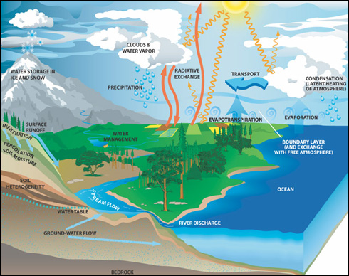
Evapotranspirationis taking place by plants and animals by which moisture is expelled to the atmosphere. Large quantity of moisture is, thus, transferred to atmosphere through the processes of bothevaporation and evapotranspiration. Because of intense insolation in tropics, convection currents are formed transferring moisture from oceanic surfaces to atmosphere. During the course of upward transfer, air expands and pressure decreases. At this stage of air ascend, not only air pressure decreases but temperature also falls down resulting in the gradual process of cooling. Consequently, relative humidity increases leading to saturation. Condensation occurs in the form of cloud formation culminating in precipitation, expressed as snowfall in higher altitudes and latitudes and rainfall in lower altitudes and tropical and temperate regions. These facts have been demonstrated in Figure 1.
Figure 1: Process of Heating and its Resultants

Source: Goh Cheng Leong (2014), p.108.
Salt Aerosols: Meteorologists are of the opinionthat very large quantities of salt particles in the form of aerosolsare injected into the atmosphere by the breaking of seawaves. When waves strike the coastal regions of a large land mass, they release a large volume of spray. Millions of minute salt particles are injected into the free atmosphere in this manner, and they act asa store house of nuclei for condensation. Salt is continuously brought into the oceans by the rivers bydraining off the continents. They carry minerals by dissolving from the rocks they run over, and deposit the same in the ocean floor. Water evaporating or freezing at the ocean’s surface leaves the remaining water saltier, but rain, which is not salty, dilutes the salt concentration of the ocean.
Figure 2: Processes of Exchange and Storage of Heat and Moisture

Feedback mechanisms: There are many feedback mechanisms between the oceans and the atmospheres. For example evaporating water can condense in the atmosphere to form clouds. These reflect both incoming and outgoing radiation. It is because of this mechanism that cloudy nights are warmer than clear ones. The system, thus determines the temperature of the ocean surface. Surface air and air aloft are in opposite motion and thus, form a circle. It helps in transferring heat and other objects to upper surface. For example moisture from oceans helps in cloud formation and precipitation. Air and water masses behave in accordance to solar energy transmitted to the surface. Such a system is well developed in tropics and gets gradually less pronounced. The most famous among such climate variations is the atmosphere’s Southern Oscillation (Walker, 1924) and its oceanic counterpart El Niño.
Walker Circulation
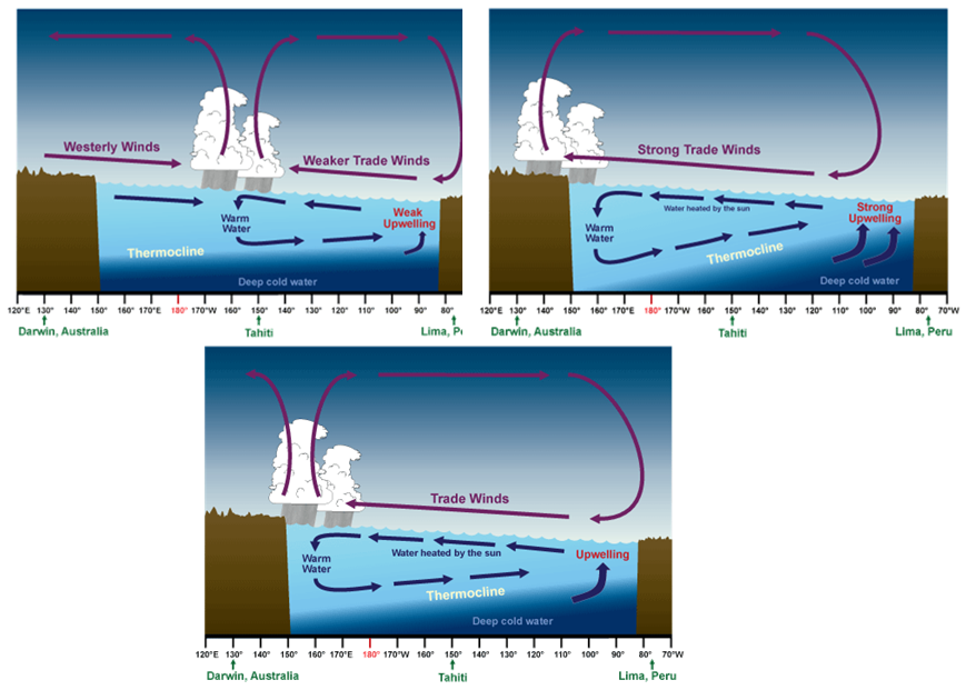
The interaction between oceanic water and atmospheric winds are closely related. Sir Gilbert Walker was the Head of the Indian Meteorological Service (1904-21). Based on observations and experiments during the course of his assignment, Sir Gilbert Walker has developed a conceptual model of air circulation in the tropics in lower atmosphere (troposphere). According to this model, parcels of air follow a closed circulation in the zonal and vertical directions. Walker circulation is also known as ‘Walker cell’. It is the result of a difference in surface air pressure and temperature over Western and Eastern Pacific Ocean. A pressure gradient from east to west causes surface air to form high pressure in Eastern Pacific to low pressure in Western Pacific (Figure 3). A line differentiating cold water layer with warm water layer is known as thermocline. The rising branch of Pacific Cell of the Walker Circulation follows on as this warm pool moves east.
Figure 3: Change in Thermocline Level and Trade Winds

Source: http://www.weather.gov.sg/wp-content/uploads/2015/03/climate2.png
Sir Walker discovered a significant relation between monsoon rain over Indian peninsula and South American pressure in April – May. He opined that overall effect of energy received from the sun was to set up impulses or natural oscillation in the atmosphere. The normal Walker circulation is represented diagrammatically in Figure 4. Accordingly Eastern Pacific Ocean remains cooler with high air pressure. The surface winds blow in east-west direction while winds aloft move in west-east direction, thus, completing the circulation cycle. On the contrary, Western Pacific Ocean becomes cool and the air over this area is denser. A high pressure is created in the Western Pacific Ocean. At the same time the Eastern Pacific becomes warmer and the air over this area is lighter and hence a low pressure is the result. Thus, the winds are in west toeast on the surface and east to west in the upper air motion. Such a situation is known as El Nino which is responsible for a weak summer monsoon in northern hemisphere. It is very clearly represented in Figure 4.
Figure 4: Walker Circulation during El Nino and Normal Condition


Atmospheric cells in Ocean-Atmosphere Interaction
Because of rotation and differential heating of the surface of the earth, air motion takes the form of cells. The air motion of the cells on the ground is opposed to the air motion aloft as it completes the cycle. The operating cells from equator to poles are three. A brief account of these cell and there role in ocean atmosphere interaction is explained below briefly.
Hadley Cell: It is named after George Hadley (1735). There is primary circulation cell known as Hadley Cell (Figure 5)and two secondary circulation cells at higher latitudes, known as Ferrel Cell, and Polar Cell (Figure 6). Hadley suggested that the distribution of solar heating would lead to rising motion in the equatorial regions and sinking motion near the poles. To compensate for the upper flow from the equator to the pole, Hadley envisaged a return flow from pole to the equator at lower latitudes. It can consist from 30 to 40 degrees north and south and is mainly responsible for the weather in the equatorial regions of the world. The Hadley Cell is a tropical atmospheric circulation that features air rising near the equator, flowing pole ward at 10-15 kilometers above the surface, descending in the subtropics and then flowing equator ward near the surface. The circulation creates the trade winds, tropical rain belts and hurricanes, subtropical deserts and the jet streams.
Figure 5: Single Cell Circulation

Ferrel Cell: William Ferrel in 1856 has pointed out the effect of earth’s rotation, or the Corialis force, on large scale movement of air. Ferrel has pointed out that Hadley’s model does not take into account the relative loss of heat from upper layers of the atmosphere. He has explained that towards higher latitudes loss of energy by long wave radiation exceeds incoming radiant energy from the sun. The loss is equivalent to a cooling of the atmosphere by about 1o to 2oC per day. There is then a middle cell between 30o N to 60o N. in which there are westerly winds at the earth’s surface and easterly winds aloft. This is known as Ferrel Cell. The location of tropopause in this cell region is about 10 kilometers from the surface.
Polar Cell: Between 600N and the pole, there lies a polar cell. The surface winds in this case are easterly and the upper winds are from a westerly direction. The Polar tropopause is located at about 8 kilometers above the surface. The model is shown schematically below in Figure 5. Thus the effect of heating and convective currents is dominant in tropics while cooling and subsiding currents dominate towards polar areas. Ferrel cell is significant as it balances the two opposite systems of air circulation.
Figure 6: Atmospheric Cells and their Interactions with Oceans

Source: https://bam.files.bbci.co.uk/bam/live/content/zyb2n39/large
Jet Streams in Ocean Atmospheric Interaction
These are narrow meandering upper air high speed winds. They play a decisive role in accelerating the dynamic situations that are conducive to transfer of energy and moisture to the atmosphere. A brief account of polar and subtropical jet is explained below:
Polar jet: The jet stream operating in polar areas modify the weather conditions significantly because of lower altitude and velocity (130 km/hour). During spring and summer season polar jets transfer energy to atmosphere effectively (Figure 7).
Subtropical jet: Popularly known as westerly jet operate in subtropical and temperate regions. The normal speed of subtropical jet ranges between 160 to 190 km/hour. It significantly improves the weather condition during winter and spring seasons in the region. The shift of subtropical jet results in improving the prospects of monsoon in tropics.
Easterly jet: These winds operate in tropical zones at a speed of 190 to 220 km/hour. Easterly – jet operate over a relatively higher altitude and also cover a larger areal extent as compared to subtropical and polar jets. They are significant in causing descend of easterly winds near subtropics during winter and south westerly monsoon winds near ITCZ during summer. As a consequence high pressure conditions develop in oceanic zones in tropics. It results and in improving the status of south west monsoon.
Figure 7: Jet Streams and Ocean – Atmosphere Interaction

Rossby Waves: C.G. Rossby (1939), a Swedish meteorologist, suggested that upper easterly winds in the middle cell are wiped out by frictional drag exerted by upper westerly winds to the north and south of the middle cell. There are many problems in the general circulation of atmosphere whose answers are not yet known. Rossby waves are also known as planetary waves. They are caused by the earth’s rotation as a natural phenomenon in atmosphere and oceans. Rossby waves are the subset of inertial waves. On the earth, these waves are giant meanders in the high altitude winds that exercise major influence on the weather. Rossby waves are associated with pressure systems and jet streams. Oceanic Rossby waves move along a thermocline. The conditions vary significantly from summer to winter season particularly in tropics. An example of temperature conditions in Indian Ocean and resultant flow of oceanic currents during summer and winter season is demonstrated through maps (Figure 8).
Figure 8: Rossby Waves in Normal, Winter and Summer Situations.

Ocean Waves and Currents: Oscillating waves continuously transfer moisture and salt particle to the atmosphere. Similarly, ocean currents transfer water, heat, and large quantities of marine biological products from equator to poles and poles to equator. In the process ocean – atmosphere maintain balance in the exchange of heat, energy and moisture. For example ocean currents in Indian Ocean flow from west to east during summer strengthening south – west summer monsoon (Figure 9). Thus, prospects of rain increase significantlyduring summer.
Figure 9: Indian Ocean Currents during summer andthesummer Monsoon.

Source: http://www.nptel.ac.in/courses/119102007/basic%20meteorology%20and%20oceanography/images/fig33.1.JPG
On the contrary ocean currents, in Indian Ocean, flow from east to west during winter season. Ocean currents in eastern coast of India coincide with the direction of north – east trade winds. As a consequence, Tamil Nadu region and its vicinity records (Figure 10) sufficient rainduring winter season while it remains dry during summer season.
Figure 10: Indian Ocean Currents during winter and prospects forwinter monsoon

Land and Sea Breezes: These are location specific breeze systems. They blow from sea to land during day time as land area gets heated quickly due to solar radiation and develops low air pressure. Sea surface, on the contrary, records high air pressure during day time because of its slow heating process. As a consequence, winds blow from sea to land and are known as ‘sea breeze’.During night, land area loss heat quickly and develop a high air pressure whereas sea surfaces remain comparatively warmer and, thus, develop a low air pressure (Figure 11). As a consequence, winds blow from land to sea during night and are known as ‘land breeze’.
Figure 11: Land and Sea Breeze in a natural setting of Day and Night.


Source: http://media1.britannica.com/eb-media/69/62669-004-5211C2BA.gif
El Nino Phases: Ocean atmosphere interaction is studied in terms of occurrence of El Nino and Southern Oscillation. The two concepts have been put together to be known as ENSO. There are two basic concepts related to ENSO phenomenon. These are: sea surface temperature (SST)and sea level pressure (SLP).The term El Niño refers to the extendedepisodes of anomalous warming of the ocean off the coast of Peru. The term Southern Oscillation refers to a sea level pressure (SLP) swing between Darwin, Australia and the island of Tahiti in the central tropical Pacific (Figure 12). Bjerknes (1969) recognized that El Niño and the Southern Oscillation (ENSO) are in fact just two different aspects of the same phenomenon, and demonstrated a remarkable correlation between Darwin atmospheric pressure and water temperature off the coast of Peru, two locations separated by the vast span of the Pacific Ocean.
Figure 12: Sea surface temperature and sea level pressure during non-El Nino and El Nino conditions

Source:http://forum.arctic-sea-ice.net/index.php?topic=730.100
Thus, ocean–atmosphere interaction is at the heart of the ENSO phenomenon. An initial change in the ocean could affect the atmosphere in such a manner that the altered atmospheric conditions, would in turn, induce oceanic changes that reinforce the initial change. The atmosphere will respond by reducing the east–west gradient of SLP, and consequently relaxing the strength of the easterly trade winds. The relaxation of the easterly winds in turn, causes an eastward surge of warm water along the equator, positively reinforcing the initial warm SST anomalies. The positive ocean–atmosphere feedback amplifies small initial perturbations into large observable amplitudes.
Considering the wide spread adverse impacts of El Nino, ten year (1985-94) international program known as Tropical Ocean and Global Atmosphere (TOGA) was launched to study the feasibility of modeling the coupled ocean-atmosphere system for predicting variations on time scales of months to years. The program has advanced the understanding, simulation, and prediction of coupled system. To improve further the prediction system, Equatorial Pacific Ocean
Climate Studies (EPOCS),Tropical Atmosphere Ocean(TAO), and TRITON were launched for the assessment of real- time thermal structure, currents and surface meteorology of the tropical Pacific.
The satellite based observations have played an important role in understanding air-sea interaction and climate research particularly in outgoing long wave radiation and SST. Space-borne microwave sensors have enabled all-weather observations of SST, rainfall, surface wind and sea surface height over the global ocean. With such a data base, there has been rapid progress in understanding and simulating the climate and its variations. Bjerknes, Manabe and Bryan were the first to work on ocean-atmosphere general circulation model. Since then, coupled ocean-atmosphere models are being used to work out interaction for ocean atmosphere circulation.
El Nino and Monsoon: The term El Niño refers to the extendedepisodes of anomalous warming of the ocean off the coast of Peru. On specific years when the sea surface temperatures (SSTs) in the equatorial eastern Pacific are anomalously warm, the east–west gradient in SST will be reduced. It results in the weakening of monsoon.
The effect of El Nino on summer monsoon is significant. El Nino is a warm Ocean current appearing along the coast of Peru. The appearance of El Nino reverts the condition of Peru current by developing warm water and moist air conditions over Eastern Pacific (Peru coast) and cold conditions in western Pacific (Eastern Australia and Indonesia). As a result, eastern Pacific along Peruvian coast in South America records high rainfall while western Pacific along Australian and Indonesian coast record drought conditions. El Nino results in weakening of the monsoon causing drought conditions and crop failures in Monsoon regions of South and South East Asia. When western Indian Ocean records low air pressure during winter and high air pressure during summer, it is said to be the positive phase of summer monsoon and sea surface conditions are normal. Heavy rains are caused in Indian subcontinent and neighboring regions during normal phase (Figure 13).
Figure 13: Impact of Positive and Negative Phases of El Nino on Summer Monsoon

La Nina and Monsoon: La Nina the word originates from Spanish meaning little girl. It is characterized by unusually cold ocean temperatures in equatorial Pacific. During the period of La Nina, sea surface temperature across equatorial eastern-central Pacific Ocean becomes lower than normal by 30 to 50 C. It has extensive effect on the weather in North America, even affecting Atlantic hurricane. La Nina causes heavy rains over Malaysia and Philippines and Indonesia. Western side of the equatorial Pacific is characterized by warm, wet low pressure weather as the collected moisture is dumped in the form of typhoons and thunderstorms. As a result of this motion, the surface water of western Pacific Coast is some 60 centimeters higher as compared to eastern Pacific Coast. The water and air returns to the east. Both of them are now much cooler and the air in the surface much drier.
Figure-14: The Phases of Normal, El Nino and La Nina Conditions


Southern Oscillations Phases
Southern oscillation is linked to low frequency temporal fluctuations in sea surface temperature in the equatorial Pacific Ocean. It is one of a number of manifestations of atmospheric fluctuations associated with alternating episodes of warm and cool sea surface temperature in the equatorial
Pacific Ocean. Its impacts are also experienced in Indian Ocean where it influences the mechanism of monsoon. If air pressure along equatorial Pacific Ocean is higher than the air pressure in Indian Ocean during winter it is said to be a ‘Positive Southern Oscillation’ indicating a favorable summer monsoon. Whenair pressure during winter is higher in Indian Ocean and lower in Pacific Ocean, it is known as ‘Negative Southern Oscillation’. Such a situation results in the weakening of summer monsoon. The intensity of southern oscillations is worked out by the difference in sea level air pressures at Tahiti ( 180 South and 149 0 west), a station in mid Pacific and port Darwin (120 South 1300 East), a representative station of Indian ocean. A negative value of ‘Southern Oscillation Index’ (SOI) implies low pressure over Peru coast and high pressure over Indian Ocean during winter season explaining a poor monsoon phase. There seems to be a close correlation between the appearance of El Nino and the negative SOI. The two adverse parameters (negative SOI and El Nino) are the cause of a weak monsoon phase. Together these parameters are known as ENSO event. Southern Oscillations has a period ranging between 2 to 7 years.
Figure-15: Southern Oscillation – Normal and El Nino conditions

Positive Southern Oscillation: It has been established that when sea level surface pressure (SLP) is high over the Pacific, air pressure over Indian Ocean tends to be low. Since surface air pressure over oceans during dry winter season is inversely related to summer rainfall; prevalence of low air pressure over Indian Ocean during winter season is considered to be a sign of ‘positive southern oscillations’. The chances of favorable monsoon are generally linked with ‘positive southern oscillations’.
Negative Southern Oscillation: The prevalence of high sea level air pressure (SLP) over Indian Ocean and low air pressure over Pacific Ocean during winter denotes the ‘negative southern oscillations’. It has been established that negative southern oscillation index (SOI) is linked with a weak monsoon phase (Figure 15).
Seasonal Cycle
Solar radiation is dominated by an annual cycle with a spatial structure that is roughly anti-symmetric near the equator. In response, the seasons in the northern hemisphere are opposite to those in the southern hemisphere. Over the oceans in the northern hemisphere, the seasonal maximum in SST generally takes place in September and March. Such a situation occurs after three months from summer and winter solstice.It is mainly due to a lag in large thermal inertia of the upper ocean. This local waxing and waning of solar radiation is a reliable predictor of seasons over most of the world except on the equator. The annual harmonic of solar radiation reaches a minimum near the equator. Thesame time, a pronounced annual cycle in SST is also observed in the eastern Pacific and Atlantic Ocean. The climatological – mean thermocline is shallow on both the locations. For example, the annual range of SST near the Galapagos Islands is about 6o C, greater than most of the tropical oceans. It is to be noted that there is a westward co-propagation of seasonal SST and zonal wind anomalies along the equator in the eastern Pacific. Significant increase from normal temperature in winters explains the occurrence of El Nino.
Conclusions
Solar heating is the basis for ocean – atmosphere interaction. The motions of the earth with reference to sun are responsible for the generation of energy and its distribution in different parts of the earth. Earth’s rotation results in causing day and night. The cycle of interaction is augmented by processes such as radiation, conduction and convection. The energy so transferred is subjected to modification by the processes such as reflection, refraction and re-radiation. The variation in the length of day results in differential receipt of solar energy, its absorption and transmission. Earth’s revolution results in causing the seasons and developing situations for the promotion of life forms.
The insolation is greatest near equator and keeps on declining towards poles. Ocean – atmospheric circulation transports energy towards poles. The resultant is the declining temperature gradient from equator to poles. Ocean and atmosphere are in constant exchange of heat, water and momentum. The interaction of the ocean and atmosphere adds rhythms in the structure of the worldclimates.
The discussion ocean–atmosphere interaction has enabled us to unlock the mysteries of ENSO and other climate phenomena, leading to skillful predictions of ENSO, its global impacts and certain aspects of tropical atmospheric variability. The success of TOGA has proved a premise that a better understanding of ocean–atmosphere interaction helps to improve model simulation, along with an adequate observing system that leads eventually to useful climate prediction.
| you can view video on OCEAN- ATMOSPHERE INTERACTION |
References
- Ferrel, W. (1856) “Professional paper” Nashville Journal of Medicine and Surgery, Vol. 12, No.7, Signal Service, USA.
- Hadley, G. (1735) Phil. Trans. Royal Society, Vol. 29, 58, London.
- Haltiner, G. (1971) Numerical Weather Prediction, Wily and Sons.
- Lorenz, E.N. (1967) The Nature and Theory of the General Circulation of the Atmosphere, WMO, Geneva, pp.1-161
- Palmen, E. and Newton, C.W. (1969) Academic Circulation Systems, Academic press.
- Rossby, C.G. (1928) Journal of Marine Research, Vol.-2, USA
- Starr, V.P., J. Peixoto and G.C. Livadas (1957) Studies of the Atmospheric General Circulation, Part – II, p.124, M.I.T, USA
- Singh, D. and Noah Diffenbaugh (2014) “South Asian Monsoon on the Change”, Nature Climate Change, Climate News Network, 4/30/2014 London.
Web Links
- http://.climateprediction.net/climate-science/glossary/atmosphere-ocean-interaction
- http://www.encyclopedia.com/earth-and-environment/atmosphere-and-weather/meteorological-instruments/atmospheric-circulation
- https://earth.stanford.edu/deeptisingh
- https://www.livescience.com/27825-jet-stream.html
- https://www.pmfias.com/jet-streams-geostrophic-wind-upper-level-westerlies/
- https://www.seas.harvard.edu/climate/eli/research/equable/hadley.html